קובץ:Baltic-Volga-Black-Caspian.png
אין גרסה ברזולוציה גבוהה יותר.
Baltic-Volga-Black-Caspian.png (340 × 458 פיקסלים, גודל הקובץ: 210 ק"ב, סוג MIME: image/png)
| זהו קובץ שמקורו במיזם ויקישיתוף. תיאורו בדף תיאור הקובץ המקורי (בעברית) מוצג למטה. |
תקציר
| תיאור |
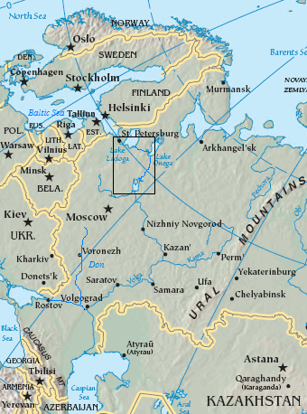
English: Map of the Volga–Baltic Waterway (boxed area).
source map modified with additional labels, box source map modified with additional labels, line drawing, box Original map cropped from https://www.cia.gov/cia/publications/factbook/reference_maps/asia.html |
| תאריך יצירה | 29 באוגוסט 2006 (תאריך העלאה מקורי) |
| מקור | הועבר מ- en.wikipedia לוויקישיתוף. |
| יוצר |
מעלה היצירה המקורי היה Jauntymcd מוויקיפדיה האנגלית |
רישיון
This image is in the public domain because it contains materials that originally came from the United States Central Intelligence Agency's World Factbook.
|
 |
This work is based on a work in the public domain. It has been digitally enhanced and/or modified. This derivative work has been (or is hereby) released into the public domain by its author, jauntymcd. This applies worldwide.
In some countries this may not be legally possible; if so: |
יומן העלאה מקורי
תיאור הקובץ המקורי נמצא כאן. כל שמות המשתמשים הבאים מתייחסים ל-en.wikipedia.
- 2006-08-29 23:28 Jauntymcd 340×458×8 (214664 bytes) source map modified with additional labels, box source map modified with additional labels, line drawing, box {{PD-retouched-user|jauntymcd}} Original map cropped from https://www.cia.gov/cia/publications/factbook/reference_maps/asia.html {{PD-USGov-CIA-
היסטוריית הקובץ
ניתן ללחוץ על תאריך/שעה כדי לראות את הקובץ כפי שנראה באותו זמן.
| תאריך/שעה | תמונה ממוזערת | ממדים | משתמש | הערה | |
|---|---|---|---|---|---|
| נוכחית | 04:32, 19 בדצמבר 2007 | | 458 × 340 (210 ק"ב) | Geanixx | {{Information |Description={{en|source map modified with additional labels, box source map modified with additional labels, line drawing, box Original map cropped from https://www.cia.gov/cia/publications/factbook/reference_maps/asia.html}} |Source=Tran |
שימוש בקובץ
הדף הבא משתמש בקובץ הזה:
שימוש גלובלי בקובץ
אתרי הוויקי השונים הבאים משתמשים בקובץ זה:
- שימוש באתר da.wikipedia.org
- שימוש באתר en.wikipedia.org
- שימוש באתר eo.wikipedia.org
- שימוש באתר es.wikipedia.org
- שימוש באתר eu.wikipedia.org
- שימוש באתר fa.wikipedia.org
- שימוש באתר it.wikipedia.org
- שימוש באתר ja.wikipedia.org
- שימוש באתר nn.wikipedia.org
- שימוש באתר no.wikipedia.org
- שימוש באתר pl.wikipedia.org
- שימוש באתר sl.wikipedia.org
- שימוש באתר uz.wikipedia.org
- שימוש באתר zh-yue.wikipedia.org
- שימוש באתר zh.wikipedia.org