קובץ:C76144s1 Ant.Map Guest Peninsula.jpg

גודל התצוגה המקדימה הזאת: 800 × 527 פיקסלים. רזולוציות אחרות: 320 × 211 פיקסלים | 640 × 422 פיקסלים | 1,024 × 675 פיקסלים | 1,280 × 843 פיקסלים | 2,560 × 1,686 פיקסלים | 4,932 × 3,249 פיקסלים.
לקובץ המקורי (4,932 × 3,249 פיקסלים, גודל הקובץ: 2.34 מ"ב, סוג MIME: image/jpeg)
| זהו קובץ שמקורו במיזם ויקישיתוף. תיאורו בדף תיאור הקובץ המקורי (בעברית) מוצג למטה. |
| תיאור |
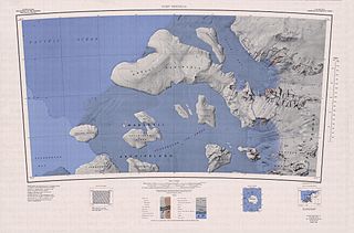
English: Map of Antarctica by the United States Antarctic Resource Center of the US Geological Society. |
| מקור | USGS |
| יוצר | USGS |
This image is in the public domain in the United States because it only contains materials that originally came from the United States Geological Survey, an agency of the United States Department of the Interior. For more information, see the official USGS copyright policy.
|
היסטוריית הקובץ
ניתן ללחוץ על תאריך/שעה כדי לראות את הקובץ כפי שנראה באותו זמן.
| תאריך/שעה | תמונה ממוזערת | ממדים | משתמש | הערה | |
|---|---|---|---|---|---|
| נוכחית | 00:40, 4 באפריל 2005 | | 3,249 × 4,932 (2.34 מ"ב) | Achim Raschka | Map of Antarctica by the United States Antarctic Ressource Center of the US Geological Society. {{PD-US}} Copyrights and Trademarks USGS-authored or produced data and information are in the public domain. While the content of most USGS web pages is in th |
שימוש בקובץ
הדפים הבאים משתמשים בקובץ הזה:
שימוש גלובלי בקובץ
אתרי הוויקי השונים הבאים משתמשים בקובץ זה:
- שימוש באתר bg.wikipedia.org
- שימוש באתר ceb.wikipedia.org
- שימוש באתר de.wikipedia.org
- Balchen-Gletscher
- Phillips Mountains
- Fosdick Mountains
- Block Bay
- Ford Ranges
- Sulzberger-Schelfeis
- Guest-Halbinsel
- Vollmer-Insel
- Cronenwett-Insel
- Marshall-Archipel
- Birchall Peaks
- Swanson Mountains
- Denfeld Mountains
- Crevasse Valley Glacier
- Chester Mountains
- Przybyszewski-Insel
- Clark Knoll
- Mount Dane
- Eilefsen Peak
- Radford Island
- Driscoll Island
- Farmer Island
- Favela Rocks
- Mount June
- Mount Perkins
- Groux Rock
- Hannah Island
- Hutchinson Island (Antarktika)
- Morris Island (Antarktika)
- Webster Bluff
- Recess-Nunatak
- שימוש באתר en.wikipedia.org
- שימוש באתר es.wikipedia.org
- שימוש באתר fr.wikipedia.org