קובץ:Canada provinces 1905-1912.png
גודל התצוגה המקדימה הזאת: 694 × 600 פיקסלים. רזולוציות אחרות: 278 × 240 פיקסלים | 556 × 480 פיקסלים | 1,000 × 864 פיקסלים.
לקובץ המקורי (1,000 × 864 פיקסלים, גודל הקובץ: 63 ק"ב, סוג MIME: image/png)
| זהו קובץ שמקורו במיזם ויקישיתוף. תיאורו בדף תיאור הקובץ המקורי (בעברית) מוצג למטה. |
תקציר
| תיאור |
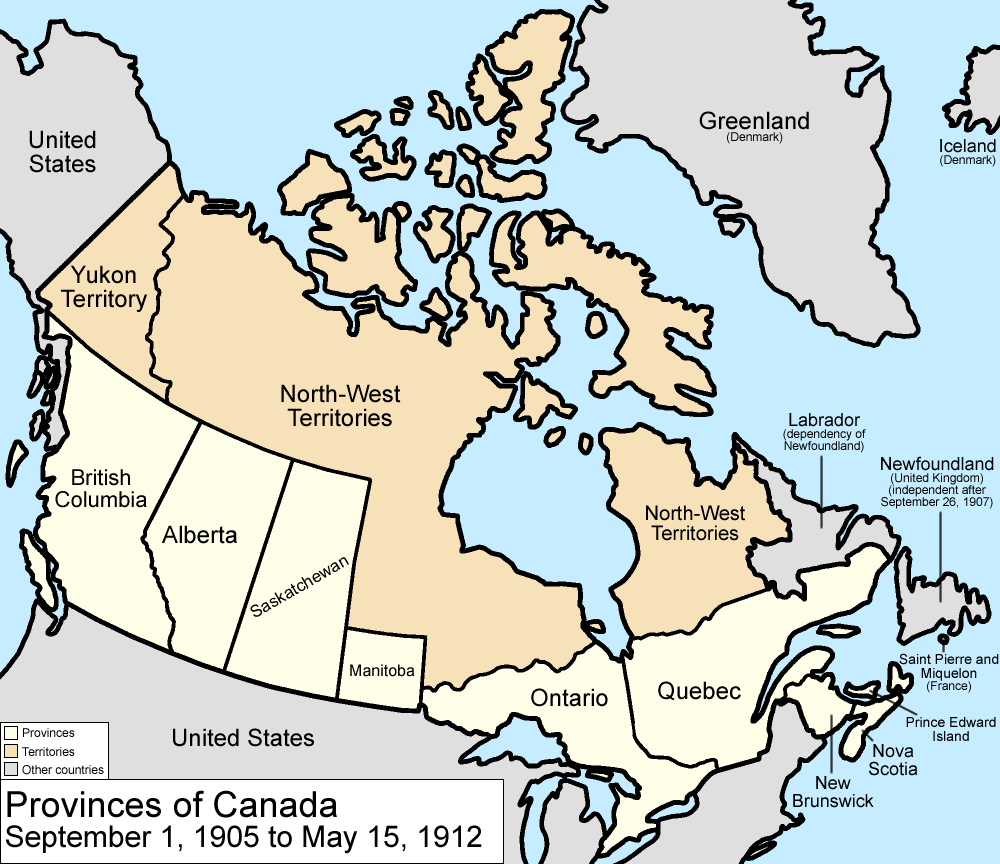
Map of the provinces and territories of Canada as they were between 1905 and 1912. On September 1 1905, Alberta and Saskatchewan were created from parts of the North-West Territories and the District of Keewatin; the remainder of the District of Keewatin was remerged into the North-West Territories. On May 15 1912, parts of the North-West Territories were given to Manitoba, Ontario, and Quebec. Also note that in 1912, the official name dropped the hyphen, changing to "Northwest Territories". Made by User:Golbez. |
| תאריך יצירה | 13 בפברואר 2006 (תאריך העלאה מקורי) |
| מקור | לא סופק מקור מכונה קריא. ההנחה היא כי היצירה נוצרה על ידי מעלה היצירה (בהתבסס על תבנית הרישיון). |
| יוצר | לא סופק יוצר ששמו ניתן לקריאה במכונה. בהתבסס על תביעות זכויות יוצרים, ההנחה היא כי Golbez הוא היוצר. |
רישיון
אני, בעל זכויות היוצרים על היצירה הזאת, מפרסם אותה בזאת תחת הרישיונות הבאים:

|
מוענקת בכך הרשות להעתיק, להפיץ או לשנות את המסמך הזה, לפי תנאי הרישיון לשימוש חופשי במסמכים של גנו, גרסה 1.2 או כל גרסה מאוחרת יותר שתפורסם על־ידי המוסד לתוכנה חופשית; ללא פרקים קבועים, ללא טקסט עטיפה קדמית וללא טקסט עטיפה אחורית. עותק של הרישיון כלול בפרק שכותרתו הרישיון לשימוש חופשי במסמכים של גנו. |
| הקובץ הזה מתפרסם לפי תנאי רישיון קריאייטיב קומונז ייחוס-שיתוף זהה 3.0 לא מותאם. | ||
| ||
| תבנית רישוי זו הוספה לקובץ כחלק מעדכון רישיון GFDL. |
הקובץ הזה מתפרסם לפי תנאי רישיון קריאייטיב קומונז ייחוס 2.5 כללי.
- הנכם רשאים:
- לשתף – להעתיק, להפיץ ולהעביר את העבודה
- לערבב בין עבודות – להתאים את העבודה
- תחת התנאים הבאים:
- ייחוס – יש לתת ייחוס הולם, לתת קישור לרישיון, ולציין אם נעשו שינויים. אפשר לעשות את זה בכל צורה סבירה, אבל לא בשום צורה שמשתמע ממנה שמעניק הרישיון תומך בך או בשימוש שלך.
הנכם מוזמנים לבחור את הרישיון הרצוי בעיניכם.
היסטוריית הקובץ
ניתן ללחוץ על תאריך/שעה כדי לראות את הקובץ כפי שנראה באותו זמן.
| תאריך/שעה | תמונה ממוזערת | ממדים | משתמש | הערה | |
|---|---|---|---|---|---|
| נוכחית | 20:22, 14 ביולי 2009 | | 864 × 1,000 (63 ק"ב) | Golbez | New color scheme, other borders |
| 12:59, 7 באוגוסט 2006 |  | 864 × 1,000 (50 ק"ב) | Golbez | with legend | |
| 05:24, 18 בפברואר 2006 |  | 864 × 1,000 (49 ק"ב) | Golbez | Better version | |
| 02:49, 14 בפברואר 2006 |  | 864 × 1,000 (43 ק"ב) | Golbez | better colors | |
| 10:14, 13 בפברואר 2006 |  | 864 × 1,000 (42 ק"ב) | Golbez | Map of the provinces and territories of Canada as they were between 1905 and 1912. On September 1 1905, Alberta and Saskatchewan were created from parts of the North-West Territories. On May 15 1912, parts of the North-West Territories were given to Manit |
שימוש בקובץ
![]() אין בוויקיפדיה דפים המשתמשים בקובץ זה.
אין בוויקיפדיה דפים המשתמשים בקובץ זה.
שימוש גלובלי בקובץ
אתרי הוויקי השונים הבאים משתמשים בקובץ זה:
- שימוש באתר arz.wikipedia.org
- שימוש באתר ast.wikipedia.org
- שימוש באתר de.wikipedia.org
- שימוש באתר en.wikipedia.org
- שימוש באתר es.wikipedia.org
- שימוש באתר fr.wikipedia.org
- שימוש באתר fy.wikipedia.org
- שימוש באתר gl.wikipedia.org
- שימוש באתר it.wikipedia.org
- שימוש באתר no.wikipedia.org
- שימוש באתר pt.wikipedia.org
- שימוש באתר ru.wikipedia.org
- שימוש באתר sv.wikipedia.org
- שימוש באתר uk.wikipedia.org
- שימוש באתר vi.wikipedia.org
- שימוש באתר www.wikidata.org
- שימוש באתר zh.wikipedia.org