קובץ:Central-eastern Brazil, by Copernicus Sentinel-2A satellite.jpg

לקובץ המקורי(11,458 × 10,980 פיקסלים, גודל הקובץ: 94.42 מ"ב, סוג MIME‏: image/jpeg)

ויקישיתוף זהו קובץ שמקורו במיזם ויקישיתוף. תיאורו בדף תיאור הקובץ המקורי (בעברית) מוצג למטה.

תקציר

Warning The original file is very high-resolution. It might not load properly or could cause your browser to freeze when opened at full size.
תיאור
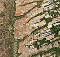
English: Central-eastern Brazil, by Copernicus Sentinel-2A satellite.

Here we can see a large, flat plateau blanked with fields benefiting from rich soils and an apparent abundance of water, before falling off into a green, hilly valley (left). The straight lines in the image are roads, such as the highway running in a nearly straight line from the centre-top to bottom of the image.

The area is particularly known for soybean production. The country’s soybean output has increased by more than 3000% since the 1970s, and Brazil is the second largest global producer of soybeans after the US.

Other crops in this area include corn, coffee and cotton.

A distinctive feature in this image is the circles – mainly at the centre. These shapes were created by a central-pivot irrigation system, where a long water pipe rotates around a well at the centre of each plot. The varying colours show different types of crop, or different stages of growth.

The two-satellite Sentinel-2 mission is designed to monitor changing lands, including crop type and health. While the first satellite has been in orbit since 2015, its Sentinel-2B twin was launched on 7 March. Together, the satellites will provide new images of Earth’s land surfaces every five days.
תאריך יצירה
מקור http://www.esa.int/spaceinimages/Images/2017/04/Central-eastern_Brazil
יוצר ESA / Copernicus Sentinel-2A

Featured תמונה

ויקישיתוף

תמונה זאת נבחרה כמומלצת בויקישיתוף (תמונות נבחרות) ונחשבת כאחת התמונות המשובחות.

אם יש ברשותכם תמונה עם איכות דומה שניתן לפרסמה תחת רישיון זכויות יוצרים מתאים, אנא העלו אותה, תייגו אותה, והציעו אותה להמלצה.

רישיון

w:he:Creative Commons
ייחוס שיתוף זהה
הנכם רשאים:
  • לשתף – להעתיק, להפיץ ולהעביר את העבודה
  • לערבב בין עבודות – להתאים את העבודה
תחת התנאים הבאים:
  • ייחוס – יש לתת ייחוס הולם, לתת קישור לרישיון, ולציין אם נעשו שינויים. אפשר לעשות את זה בכל צורה סבירה, אבל לא בשום צורה שמשתמע ממנה שמעניק הרישיון תומך בך או בשימוש שלך.
  • שיתוף זהה – אם תיצרו רמיקס, תשנו, או תבנו על החומר, חובה עליכם להפיץ את התרומות שלך לפי תנאי רישיון זהה או תואם למקור.
This file, which was originally posted to http://www.esa.int/spaceinimages/Images/2017/04/Central-eastern_Brazil, was reviewed on 6 May 2017 by reviewer Daphne Lantier, who confirmed that it was available there under the stated license on that date.
© This image contains data from a satellite in the Copernicus Programme, such as Sentinel-1, Sentinel-2 or Sentinel-3. Attribution is required when using this image.
ייחוס: Contains modified Copernicus Sentinel data 2016

The use of Copernicus Sentinel Data is regulated under EU law (Commission Delegated Regulation (EU) No 1159/2013 and Regulation (EU) No 377/2014). Relevant excerpts:


Financial conditions

Free access shall be given to GMES dedicated data [...] made available through GMES dissemination platforms [...].

Conditions regarding use

Access to GMES dedicated data [...] shall be given for the purpose of the following use in so far as it is lawful:

  1. reproduction;
  2. distribution;
  3. communication to the public;
  4. adaptation, modification and combination with other data and information;
  5. any combination of points (a) to (d).

GMES dedicated data [...] may be used worldwide without limitations in time.

Conditions regarding information to be given by users
  1. When distributing or communicating GMES dedicated data [...] to the public, users shall inform the public of the source of that data and information.
  2. Users shall make sure not to convey the impression to the public that the user’s activities are officially endorsed by the Union.
  3. Where that data or information has been adapted or modified, the user shall clearly state this.
Absence of warranty

GMES dedicated data and GMES service information are provided to users without any express or implied warranty, including as regards quality and suitability for any purpose.

כיתובים

נא להוסיף משפט שמסביר מה הקובץ מייצג

פריטים שמוצגים בקובץ הזה

מוצג

image/jpeg

checksum אנגלית

860b7590190d304c92c5b201af7f153b579ee130

הוגדר לפי: SHA-1 אנגלית

99,007,576 בית

10,980 פיקסל

11,458 פיקסל

היסטוריית הקובץ

ניתן ללחוץ על תאריך/שעה כדי לראות את הקובץ כפי שנראה באותו זמן.

תאריך/שעהתמונה ממוזערתממדיםמשתמשהערה
נוכחית13:45, 12 ביוני 2020תמונה ממוזערת לגרסה מ־13:45, 12 ביוני 2020‪10,980 × 11,458‬ (94.42 מ"ב)The RedBurnColor balance
01:03, 6 במאי 2017תמונה ממוזערת לגרסה מ־01:03, 6 במאי 2017‪10,980 × 11,458‬ (92.43 מ"ב)Yannc:User:Rillke/bigChunkedUpload.js: HR from TIFF, 98% compression
23:24, 5 במאי 2017תמונה ממוזערת לגרסה מ־23:24, 5 במאי 2017‪1,840 × 1,920‬ (3.84 מ"ב)YannTransferred from http://www.esa.int/var/esa/storage/images/esa_multimedia/images/2017/04/central-eastern_brazil/16900171-1-eng-GB/Central-eastern_Brazil.jpg

הדף הבא משתמש בקובץ הזה:

שימוש גלובלי בקובץ

אתרי הוויקי השונים הבאים משתמשים בקובץ זה:

מטא־נתונים