קובץ:CircumnavigationByTrades.png
CircumnavigationByTrades.png (800 × 500 פיקסלים, גודל הקובץ: 287 ק"ב, סוג MIME: image/png)
| זהו קובץ שמקורו במיזם ויקישיתוף. תיאורו בדף תיאור הקובץ המקורי (בעברית) מוצג למטה. |
תקציר
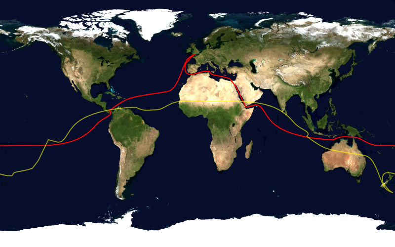
This image shows the route, in red, of a typical sailing circumnavigation of the world via the Panama Canal and Suez Canal, making use of the trade winds. Shown in yellow is the antipodean point of each point on the route; it can be seen that a boat following this route will pass through several points antipodean to each other, thus satisfying one definition of a circumnavigation.
This image was constructed from a public domain Visible Earth product of the Earth Observatory office of the United States government space agency NASA. It is based on a cylindrical equi-distant projection.
רישיון
| קובץ זה בנחלת הכלל כי הוא צילום מסך מתוכנת תוכנת הגלובוס של נאס"א, שעושה שימוש במרכיבים שנמצאים ברשות הציבור כמו: The Blue Marble, MODIS, Landsat, SRTM, USGS או GLOBE.
|
 |
היסטוריית הקובץ
ניתן ללחוץ על תאריך/שעה כדי לראות את הקובץ כפי שנראה באותו זמן.
| תאריך/שעה | תמונה ממוזערת | ממדים | משתמש | הערה | |
|---|---|---|---|---|---|
| נוכחית | 19:03, 23 בינואר 2006 | | 500 × 800 (287 ק"ב) | Johantheghost | This image shows the route, in red, of a typical sailing circumnavigation of the world via the Panama Canal and Suez Canal, making use of the [[Wikipe |
שימוש בקובץ
הדפים הבאים משתמשים בקובץ הזה:
שימוש גלובלי בקובץ
אתרי הוויקי השונים הבאים משתמשים בקובץ זה:
- שימוש באתר ast.wikipedia.org
- שימוש באתר da.wikipedia.org
- שימוש באתר en.wikipedia.org
- שימוש באתר eo.wikipedia.org
- שימוש באתר es.wikipedia.org
- שימוש באתר fi.wikipedia.org
- שימוש באתר ja.wikipedia.org
- שימוש באתר ko.wikipedia.org
- שימוש באתר la.wikipedia.org
- שימוש באתר nl.wikipedia.org
- שימוש באתר nn.wikipedia.org
- שימוש באתר no.wikipedia.org
- שימוש באתר pl.wikipedia.org
- שימוש באתר pt.wikipedia.org
- שימוש באתר ru.wikipedia.org
- שימוש באתר simple.wikipedia.org