קובץ:Democratic Republic of Georgia map.jpg
גודל התצוגה המקדימה הזאת: 800 × 561 פיקסלים. רזולוציות אחרות: 320 × 224 פיקסלים | 640 × 448 פיקסלים | 1,024 × 718 פיקסלים | 1,213 × 850 פיקסלים.
לקובץ המקורי (1,213 × 850 פיקסלים, גודל הקובץ: 442 ק"ב, סוג MIME: image/jpeg)
| זהו קובץ שמקורו במיזם ויקישיתוף. תיאורו בדף תיאור הקובץ המקורי (בעברית) מוצג למטה. |

|
יש ליצור מחדש את התמונה history map הזו באמצעות גרפיקה וקטורית כדוגמת קובץ SVG. לפעולה זו מספר יתרונות, כפי שניתן לקרוא (באנגלית) בדף Commons:Media for cleanup. אם ברשותכם קובץ SVG, אנא העלו אותו. לאחר מכן, החליפו תבנית זו בתבנית
{{vector version available|שם הקובץ.svg}} |


תקציר
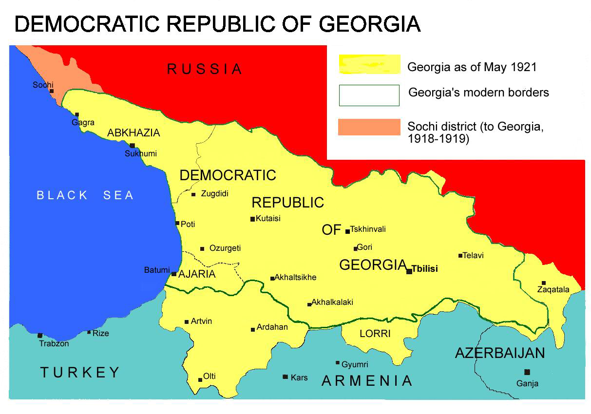
Democratic Republic of Georgia map, 1918-1921
Source: english wikipedia
Uploaded by user:Kober
רישיון
| ברצוני, בעלי זכויות היוצרים על יצירה זו, לשחרר יצירה זו לנחלת הכלל. זה תקף בכל העולם. יש מדינות שבהן הדבר אינו אפשרי על פי חוק, אם כך: אני מעניק לכל אחד את הזכות להשתמש בעבודה זו לכל מטרה שהיא, ללא תנאים כלשהם, אלא אם כן תנאים כאלה נדרשים על פי חוק. |
היסטוריית הקובץ
ניתן ללחוץ על תאריך/שעה כדי לראות את הקובץ כפי שנראה באותו זמן.
| תאריך/שעה | תמונה ממוזערת | ממדים | משתמש | הערה | |
|---|---|---|---|---|---|
| נוכחית | 16:26, 7 באפריל 2013 | | 850 × 1,213 (442 ק"ב) | Giorgi Balakhadze | At that time (May, 1921 year) there was no South Ossetia, it was created in 1922. |
| 16:21, 7 באפריל 2013 |  | 850 × 1,213 (442 ק"ב) | Giorgi Balakhadze | Reverted to version as of 13:08, 7 April 2013 | |
| 16:15, 7 באפריל 2013 |  | 850 × 1,213 (442 ק"ב) | Giorgi Balakhadze | At that time (1921 year) there was no South Ossetia, it was created 1922. | |
| 16:08, 7 באפריל 2013 |  | 850 × 1,213 (442 ק"ב) | Giorgi Balakhadze | At that time (1921 year) there was no South Osetia. | |
| 19:46, 26 בדצמבר 2005 |  | 850 × 1,213 (111 ק"ב) | Hardscarf | Democratic Republic of Georgia map, 1918-1921 Source: [http://en.wikipedia.org/wiki/Image:Democratic_Republic_of_Georgia_map.jpg english wikipedia] Uploaded by [http://en.wikipedia.org/wiki/User:Kober user:Kober] Category:Historical maps of Georgia |
שימוש בקובץ
![]() אין בוויקיפדיה דפים המשתמשים בקובץ זה.
אין בוויקיפדיה דפים המשתמשים בקובץ זה.
שימוש גלובלי בקובץ
אתרי הוויקי השונים הבאים משתמשים בקובץ זה:
- שימוש באתר bg.wikipedia.org
- שימוש באתר bn.wikipedia.org
- שימוש באתר da.wikipedia.org
- שימוש באתר de.wikipedia.org
- שימוש באתר en.wikipedia.org
- שימוש באתר en.wikibooks.org
- שימוש באתר fa.wikipedia.org
- שימוש באתר id.wikipedia.org
- שימוש באתר ka.wikipedia.org
- שימוש באתר lt.wikipedia.org
- שימוש באתר pl.wikipedia.org
- שימוש באתר pnb.wikipedia.org
- שימוש באתר pt.wikipedia.org
- שימוש באתר ru.wikipedia.org
- שימוש באתר sk.wikipedia.org
- שימוש באתר sr.wikipedia.org
- שימוש באתר tr.wikipedia.org
- שימוש באתר uk.wikipedia.org
- שימוש באתר ur.wikipedia.org
- שימוש באתר zh.wikipedia.org