קובץ:Despotate of Morea 1450.svg

גודל התצוגה המקדימה הזאת מסוג PNG של קובץ ה־SVG הזה: 643 × 599 פיקסלים. רזולוציות אחרות: 258 × 240 פיקסלים | 515 × 480 פיקסלים | 824 × 768 פיקסלים | 1,099 × 1,024 פיקסלים | 2,198 × 2,048 פיקסלים | 1,303 × 1,214 פיקסלים.
לקובץ המקורי (קובץ SVG, הגודל המקורי: 1,303 × 1,214 פיקסלים, גודל הקובץ: 208 ק"ב)
| זהו קובץ שמקורו במיזם ויקישיתוף. תיאורו בדף תיאור הקובץ המקורי (בעברית) מוצג למטה. |
תקציר
| תיאור |
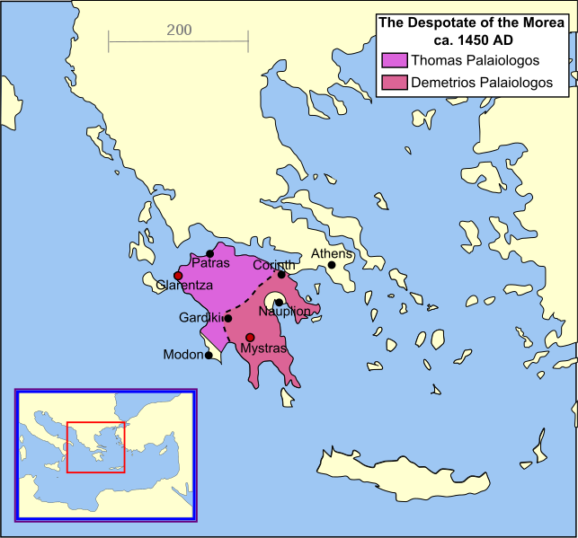
English: A map of the Despotate of the Morea in the year 1450. |
| תאריך יצירה | |
| מקור | נוצר על־ידי מעלה היצירה |
| יוצר | MapMaster |
| גרסאות אחרות |
[]
|


References
- Shepherd's map of the Ottoman Empire, 1451 - 1481.[dead link]
- Vakalopoulos, Apostolos E. Ιστορία του νέου ελληνισμού, Τόμος Α′: Αρχές και διαμόρφωσή του (Έκδοση Β′) [History of modern Hellenism, Volume I: Its origins and formation (2nd Edition)] Thessaloniki 1974, p. 343
- Bjorklund, Oddvar; Holmboe, Haakon; Rohr, Anders (1970) Historical Atlas of the World, Barnes & Noble, NY, SBN: 389-00253-4.
- Matthew, Donald, (1983), Atlas of Medieval Europe, Checkmark Books, New York.
- Image:Europe in 1430.PNG
See also
derivative works
Derivative works of this file: Despotate of Morea 1450 es.svg
רישיון
אני, בעל זכויות היוצרים על היצירה הזאת, מפרסם אותה בזאת תחת הרישיונות הבאים:

|
מוענקת בכך הרשות להעתיק, להפיץ או לשנות את המסמך הזה, לפי תנאי הרישיון לשימוש חופשי במסמכים של גנו, גרסה 1.2 או כל גרסה מאוחרת יותר שתפורסם על־ידי המוסד לתוכנה חופשית; ללא פרקים קבועים, ללא טקסט עטיפה קדמית וללא טקסט עטיפה אחורית. עותק של הרישיון כלול בפרק שכותרתו הרישיון לשימוש חופשי במסמכים של גנו. |
| הקובץ הזה מתפרסם לפי תנאי רישיון קריאייטיב קומונז ייחוס-שיתוף זהה 3.0 לא מותאם. | ||
| ||
| תבנית רישוי זו הוספה לקובץ כחלק מעדכון רישיון GFDL. |
הקובץ הזה מתפרסם לפי תנאי רישיון קריאייטיב קומונז ייחוס-שיתוף זהה 2.5 כללי.
- הנכם רשאים:
- לשתף – להעתיק, להפיץ ולהעביר את העבודה
- לערבב בין עבודות – להתאים את העבודה
- תחת התנאים הבאים:
- ייחוס – יש לתת ייחוס הולם, לתת קישור לרישיון, ולציין אם נעשו שינויים. אפשר לעשות את זה בכל צורה סבירה, אבל לא בשום צורה שמשתמע ממנה שמעניק הרישיון תומך בך או בשימוש שלך.
- שיתוף זהה – אם תיצרו רמיקס, תשנו, או תבנו על החומר, חובה עליכם להפיץ את התרומות שלך לפי תנאי רישיון זהה או תואם למקור.
הנכם מוזמנים לבחור את הרישיון הרצוי בעיניכם.
היסטוריית הקובץ
ניתן ללחוץ על תאריך/שעה כדי לראות את הקובץ כפי שנראה באותו זמן.
| תאריך/שעה | תמונה ממוזערת | ממדים | משתמש | הערה | |
|---|---|---|---|---|---|
| נוכחית | 13:03, 27 ביוני 2011 | | 1,214 × 1,303 (208 ק"ב) | Cplakidas | improved version, showing major towns as well as the division of the Despotate between the brothers Tomas and Demetrios after 1450 |
| 05:04, 17 בספטמבר 2007 |  | 1,214 × 1,303 (131 ק"ב) | MapMaster | border changes based on discussion with Alekkas (see Image talk:Eastern Mediterranean 1450 .svg) | |
| 16:31, 14 באפריל 2007 |  | 1,214 × 1,303 (133 ק"ב) | MapMaster | Better colour | |
| 08:30, 14 באפריל 2007 |  | 1,214 × 1,303 (134 ק"ב) | MapMaster | A "locator" (text- and language-free) map of the Despotate of Morea in the year 1450. Category:Maps of the history of Greece |
שימוש בקובץ
הדף הבא משתמש בקובץ הזה:
שימוש גלובלי בקובץ
אתרי הוויקי השונים הבאים משתמשים בקובץ זה:
- שימוש באתר als.wikipedia.org
- שימוש באתר az.wikipedia.org
- שימוש באתר be.wikipedia.org
- שימוש באתר bg.wikipedia.org
- שימוש באתר ca.wikipedia.org
- שימוש באתר cs.wikipedia.org
- שימוש באתר de.wikipedia.org
- שימוש באתר el.wikipedia.org
- שימוש באתר en.wikipedia.org
- שימוש באתר eo.wikipedia.org
- שימוש באתר et.wikipedia.org
- שימוש באתר fa.wikipedia.org
- שימוש באתר fi.wikipedia.org
- שימוש באתר fr.wikipedia.org
- שימוש באתר gl.wikipedia.org
- שימוש באתר hu.wikipedia.org
- שימוש באתר hy.wikipedia.org
- שימוש באתר id.wikipedia.org
- שימוש באתר ja.wikipedia.org
- שימוש באתר ka.wikipedia.org
- שימוש באתר lt.wikipedia.org