קובץ:Detailed Afroasiatic map.svg

גודל התצוגה המקדימה הזאת מסוג PNG של קובץ ה־SVG הזה: 800 × 503 פיקסלים. רזולוציות אחרות: 320 × 201 פיקסלים | 640 × 402 פיקסלים | 1,024 × 644 פיקסלים | 1,280 × 805 פיקסלים | 2,560 × 1,609 פיקסלים | 1,750 × 1,100 פיקסלים.
לקובץ המקורי (קובץ SVG, הגודל המקורי: 1,750 × 1,100 פיקסלים, גודל הקובץ: 471 ק"ב)
| זהו קובץ שמקורו במיזם ויקישיתוף. תיאורו בדף תיאור הקובץ המקורי (בעברית) מוצג למטה. |
תקציר
| תיאור |
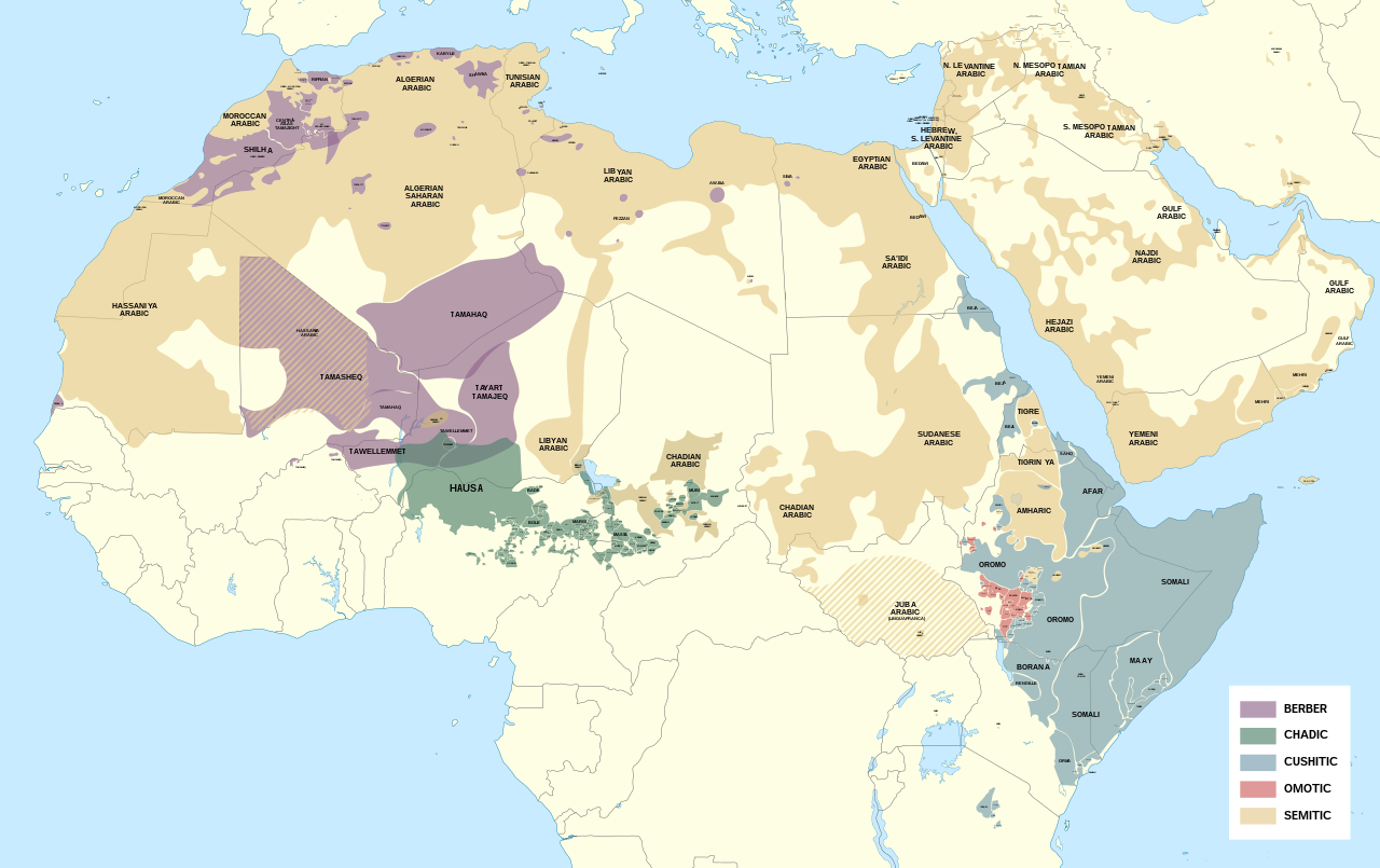
English: Detailed map of Afroasiatic languages in Africa and the Middle East.
קובץ זה הוא יצירה נגזרת של: Africa map blank.svg Sources (Wikipedia): External sources:
|
| תאריך יצירה | |
| מקור | נוצר על־ידי מעלה היצירה |
| יוצר | Noahedits |
![[1]](https://i.pinimg.com/originals/62/b9/94/62b994c3798bc258992de42c46e186fd.png)
![[2]](http://languages.y-bai.com/img/language_map/irq.png)
![[3]](https://i.pinimg.com/564x/8f/52/24/8f522431ee622097dc2550d9ff80480c.jpg)
![[4]](https://i.pinimg.com/originals/d7/88/71/d7887182da05cf42771989eb93960e99.png)
![[5]](https://www.ethnologue.com/sites/default/files/styles/original/public/maps/20/KE_rgb.png?itok=yGwj_XnA)
![[7]](https://www.ethnologue.com/17/sites/default/files/styles/original/public/maps/17/NG_01_rgb/index.png?itok=n1EYvDsI)
![[8]](https://www.ethnologue.com/18/sites/default/files/styles/original/public/maps/18/NG_07_rgb.png?itok=a23BiwQy)
![[9]](https://www.researchgate.net/profile/Adeiza_Isiaka/publication/317208410/figure/fig1/AS:536272059416576@1504868630079/An-index-map-for-some-Nigerian-languages-Ebira-302-is-mainly-spoken-around.png)
![[10]](https://www.researchgate.net/profile/Scott_Maceachern/publication/236160990/figure/fig2/AS:299342981287937@1448380336585/Languages-of-northern-Cameroon-Map-is-the-property-of-SIL-International-and-was-accessed.png)
![[11]](https://asmarttranslatorsreunion.files.wordpress.com/2015/11/om_rgb.png?w=584&h=889)
![[12]](https://1.bp.blogspot.com/-BeNgqhpZtGo/U3LO9MGkfOI/AAAAAAAAIqw/C4np8aWpWdQ/s1600/YE_rgb.png)
![[14]](https://i.pinimg.com/originals/89/42/66/894266f083206db69405d21bc93811a5.png)
![[16]](https://static.cambridge.org/binary/version/id/urn:cambridge.org:id:binary:20190522054803538-0373:9781108283991:41798map10_1.png?pub-status=live)
רישיון
אני, בעל זכויות היוצרים על עבודה זו, מפרסם בזאת את העבודה תחת הרישיון הבא:
הקובץ הזה מתפרסם לפי תנאי רישיון קריאייטיב קומונז ייחוס-שיתוף זהה 4.0 בין־לאומי.
- הנכם רשאים:
- לשתף – להעתיק, להפיץ ולהעביר את העבודה
- לערבב בין עבודות – להתאים את העבודה
- תחת התנאים הבאים:
- ייחוס – יש לתת ייחוס הולם, לתת קישור לרישיון, ולציין אם נעשו שינויים. אפשר לעשות את זה בכל צורה סבירה, אבל לא בשום צורה שמשתמע ממנה שמעניק הרישיון תומך בך או בשימוש שלך.
- שיתוף זהה – אם תיצרו רמיקס, תשנו, או תבנו על החומר, חובה עליכם להפיץ את התרומות שלך לפי תנאי רישיון זהה או תואם למקור.
היסטוריית הקובץ
ניתן ללחוץ על תאריך/שעה כדי לראות את הקובץ כפי שנראה באותו זמן.
| תאריך/שעה | תמונה ממוזערת | ממדים | משתמש | הערה | |
|---|---|---|---|---|---|
| נוכחית | 20:35, 13 במאי 2022 | | 1,100 × 1,750 (471 ק"ב) | Noahedits | Removing Somaliland (not recognized by the international community) |
| 03:54, 19 באוקטובר 2021 |  | 1,100 × 1,750 (549 ק"ב) | Gebagebo | Added Somaliland | |
| 22:19, 16 במאי 2020 |  | 1,100 × 1,750 (471 ק"ב) | Noahedits | Fixed error in Lake Victoria, cleaned up stray lines | |
| 20:33, 23 באפריל 2020 |  | 322 × 512 (484 ק"ב) | Noahedits | Adjusted location of Borana and Burji | |
| 00:04, 2 באפריל 2020 |  | 322 × 512 (447 ק"ב) | Noahedits | Detail in central Arabian peninsula | |
| 01:02, 8 בפברואר 2020 |  | 325 × 512 (491 ק"ב) | Noahedits | Cleaned up northern Iraq/Syira, fixed misidentification of Beja | |
| 09:06, 7 בפברואר 2020 |  | 325 × 512 (480 ק"ב) | Noahedits | Title, legend, slight clean up | |
| 08:41, 7 בפברואר 2020 |  | 325 × 512 (479 ק"ב) | Noahedits | User created page with UploadWizard |
שימוש בקובץ
הדף הבא משתמש בקובץ הזה:
שימוש גלובלי בקובץ
אתרי הוויקי השונים הבאים משתמשים בקובץ זה:
- שימוש באתר ar.wikipedia.org
- שימוש באתר el.wikipedia.org
- שימוש באתר en.wikipedia.org
- שימוש באתר es.wikipedia.org
- שימוש באתר fa.wikipedia.org
- שימוש באתר fy.wikipedia.org
- שימוש באתר gl.wikipedia.org
- שימוש באתר ie.wikipedia.org
- שימוש באתר it.wikipedia.org
- שימוש באתר ja.wikipedia.org
- שימוש באתר lij.wikipedia.org
- שימוש באתר mzn.wikipedia.org
- שימוש באתר ne.wikipedia.org
- שימוש באתר oc.wikipedia.org
- שימוש באתר sat.wikipedia.org
- שימוש באתר simple.wikipedia.org
- שימוש באתר si.wikipedia.org
- שימוש באתר sr.wikipedia.org
- שימוש באתר sv.wikipedia.org
- שימוש באתר tr.wikipedia.org