קובץ:Europe 814.png

גודל התצוגה המקדימה הזאת: 777 × 600 פיקסלים. רזולוציות אחרות: 311 × 240 פיקסלים | 622 × 480 פיקסלים | 995 × 768 פיקסלים | 1,280 × 988 פיקסלים | 1,393 × 1,075 פיקסלים.
לקובץ המקורי (1,393 × 1,075 פיקסלים, גודל הקובץ: 169 ק"ב, סוג MIME: image/png)
| זהו קובץ שמקורו במיזם ויקישיתוף. תיאורו בדף תיאור הקובץ המקורי (בעברית) מוצג למטה. |

תקציר
| תיאור |
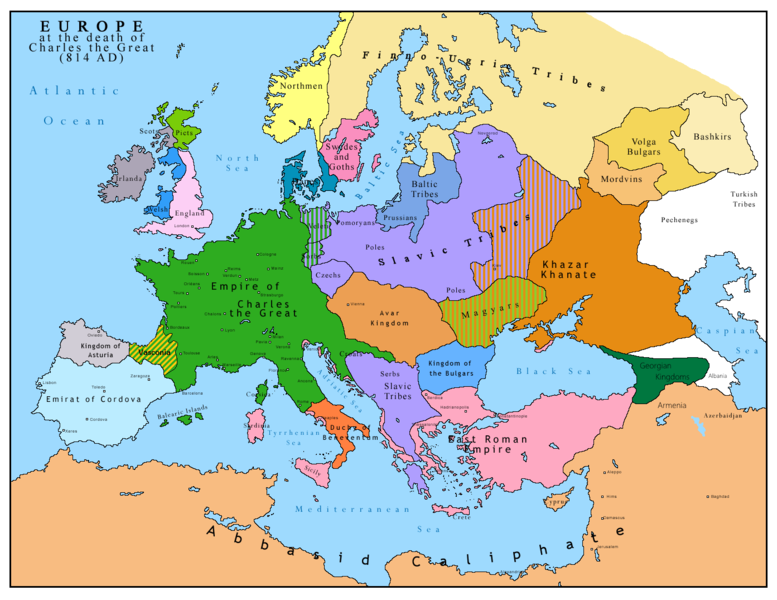
English: Map of Europe after the death of Charles the Great (814 AD). Original map made by Charles Colbeck, The Public Schools Historical Atlas (1905). |
|||
| תאריך יצירה | 2009-04-15. Source date: 1905 by Longmans, Green; New York, London, Bombay 1905. | |||
| מקור | נוצר על ידי מעלה היצירה בהתבסס על: Europe 814.jpg | |||
| יוצר | Bukkia (שיחה · תרומות) | |||
| גרסאות אחרות |
|


רישיון
| ברצוני, בעלי זכויות היוצרים על יצירה זו, לשחרר יצירה זו לנחלת הכלל. זה תקף בכל העולם. יש מדינות שבהן הדבר אינו אפשרי על פי חוק, אם כך: אני מעניק לכל אחד את הזכות להשתמש בעבודה זו לכל מטרה שהיא, ללא תנאים כלשהם, אלא אם כן תנאים כאלה נדרשים על פי חוק. |
_en.png)
.png)
.jpg)
היסטוריית הקובץ
ניתן ללחוץ על תאריך/שעה כדי לראות את הקובץ כפי שנראה באותו זמן.
| תאריך/שעה | תמונה ממוזערת | ממדים | משתמש | הערה | |
|---|---|---|---|---|---|
| נוכחית | 14:09, 26 באפריל 2023 | | 1,075 × 1,393 (169 ק"ב) | OrionNimrod | Reverted to version as of 13:52, 23 December 2015 (UTC) restore |
| 19:09, 2 במאי 2019 |  | 1,047 × 1,370 (124 ק"ב) | Julieta39 | Slavs also in the Avars and Bulgars kingdoms | |
| 16:52, 23 בדצמבר 2015 |  | 1,075 × 1,393 (169 ק"ב) | Ercwlff | at that time armenia was already part of Arab caliphate.. and there were several Georgian kingdoms or principalities in the north of them | |
| 16:52, 8 ביוני 2015 |  | 1,075 × 1,393 (157 ק"ב) | Zorion | Vasconia in rebellion | |
| 20:49, 28 במאי 2015 |  | 1,075 × 1,393 (156 ק"ב) | Zorion | From 812 to 824, Vasconia was ruled by Vascons (sourced can be found anywhere in spanish, basque or french). This map was wrong for that specific year. Seems that historian wanted to credit a famous king but, he was dead when Wasconia got back under th... | |
| 18:58, 24 באוגוסט 2014 |  | 1,075 × 1,393 (230 ק"ב) | Martin H. | Reverted to version as of 14:53, 31 January 2010: File is consistent with its source file File:Europe 814.jpg; change conflicts with en:Duchy_of_Vasconia#Carolingian duchy (769–864) | |
| 17:42, 24 באוגוסט 2014 |  | 1,075 × 1,393 (156 ק"ב) | Zorion | Vasconia was independant from frankish kingdom until 824 | |
| 17:53, 31 בינואר 2010 |  | 1,075 × 1,393 (230 ק"ב) | Bukkia | == {{int:filedesc}} == {{Information |Description={{it|1=Mappa dell'Europa alla morte di Carlo Magno (814 d.C.)}} {{en|1=Map of Europe after the death of Charles the Great (814 AD, in Italian)}} |Source=Based on File:Europe 814.jpg |Author=[[user:Buk |
שימוש בקובץ
הדף הבא משתמש בקובץ הזה:
שימוש גלובלי בקובץ
אתרי הוויקי השונים הבאים משתמשים בקובץ זה:
- שימוש באתר arz.wikipedia.org
- שימוש באתר bo.wikipedia.org
- שימוש באתר da.wikipedia.org
- שימוש באתר de.wikipedia.org
- שימוש באתר el.wikipedia.org
- שימוש באתר en.wikipedia.org
- שימוש באתר es.wikipedia.org
- שימוש באתר fa.wikipedia.org
- שימוש באתר fr.wikipedia.org
- שימוש באתר gl.wikipedia.org
- שימוש באתר hu.wikipedia.org
- שימוש באתר hy.wikipedia.org
- שימוש באתר id.wikipedia.org
- שימוש באתר it.wikipedia.org
- שימוש באתר ko.wikipedia.org
- שימוש באתר lmo.wikipedia.org
- שימוש באתר lv.wikipedia.org
- שימוש באתר mk.wikipedia.org
- שימוש באתר pl.wikipedia.org
- שימוש באתר ro.wikipedia.org
- שימוש באתר sh.wikipedia.org
- שימוש באתר sr.wikipedia.org
- שימוש באתר sw.wikipedia.org
- שימוש באתר uk.wikipedia.org