קובץ:Former Yugoslavia 2006.svg

גודל התצוגה המקדימה הזאת מסוג PNG של קובץ ה־SVG הזה: 800 × 499 פיקסלים. רזולוציות אחרות: 320 × 199 פיקסלים | 640 × 399 פיקסלים | 1,024 × 638 פיקסלים | 1,280 × 798 פיקסלים | 2,560 × 1,596 פיקסלים | 1,832 × 1,142 פיקסלים.
לקובץ המקורי (קובץ SVG, הגודל המקורי: 1,832 × 1,142 פיקסלים, גודל הקובץ: 617 ק"ב)
| זהו קובץ שמקורו במיזם ויקישיתוף. תיאורו בדף תיאור הקובץ המקורי (בעברית) מוצג למטה. |
Authors:
תקציר
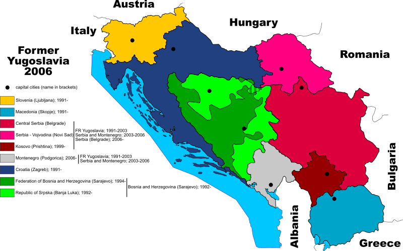
Polski: Mapa byłej Jugosławii, z uwzględnieniem podziału Serbii na Wojwodinę i Kosowo, oraz podziału Bośni i Hercegowiny na dwie składowe części. Stan na czerwiec 2006 roku. (plska wersja)
.svg&action=edit&redlink=1)
English: Map of former Yugoslavia with division of Bosnia-Herzegovina. June 2006
. Inkscape עם נוצרה ה תמונה

|
The file size of this SVG image may be abnormally large because most or all of its text has been converted to paths rather than using the more conventional
<text> element. Unless rendering the text of the SVG file produces an image with text that is incurably unreadable due to technical limitations, it is highly recommended to change the paths back to text. Doing so will ease the process of localizing this image to other languages and is likely to reduce the file size in a significant scale. Other SVGs containing path-based text can be found at Category:Path text SVG. For more information, see SVG: Fonts and Preparing images for upload: Text.
|

|
רישיון

|
מוענקת בכך הרשות להעתיק, להפיץ או לשנות את המסמך הזה, לפי תנאי הרישיון לשימוש חופשי במסמכים של גנו, גרסה 1.2 או כל גרסה מאוחרת יותר שתפורסם על־ידי המוסד לתוכנה חופשית; ללא פרקים קבועים, ללא טקסט עטיפה קדמית וללא טקסט עטיפה אחורית. עותק של הרישיון כלול בפרק שכותרתו הרישיון לשימוש חופשי במסמכים של גנו. |
| הקובץ הזה מתפרסם לפי תנאי רישיון קריאייטיב קומונז ייחוס-שיתוף זהה 3.0 לא מותאם. | ||
| ||
| תבנית רישוי זו הוספה לקובץ כחלק מעדכון רישיון GFDL. |
היסטוריית הקובץ
ניתן ללחוץ על תאריך/שעה כדי לראות את הקובץ כפי שנראה באותו זמן.
| תאריך/שעה | תמונה ממוזערת | ממדים | משתמש | הערה | |
|---|---|---|---|---|---|
| נוכחית | 14:27, 26 ביוני 2006 | | 1,142 × 1,832 (617 ק"ב) | Shazz | ==Authors:== *Based on bitmap by: Paweł Goleniowski swPawel *SVG by: ** commons: Shazz ** pl.wiki: Shazz ==Description== * '''pl:''' Mapa byłej Jugosławii, z uwzględnieniem podziału Serbii na Wojwo |
| 11:53, 21 ביוני 2006 |  | 1,142 × 1,832 (613 ק"ב) | Shazz | ==Authors:== *Based on bitmap by: swPawel *SVG by: ** commons: Shazz ** pl.wiki: Shazz ==Description== * '''pl:''' Mapa byłej Jugosławii, z uwzględnieniem podziału Serbii na Wojwodinę i Kosowo, ora |
שימוש בקובץ
![]() אין בוויקיפדיה דפים המשתמשים בקובץ זה.
אין בוויקיפדיה דפים המשתמשים בקובץ זה.
שימוש גלובלי בקובץ
אתרי הוויקי השונים הבאים משתמשים בקובץ זה:
- שימוש באתר bh.wikipedia.org
- שימוש באתר ca.wikipedia.org
- שימוש באתר en.wikipedia.org
- שימוש באתר es.wikipedia.org
- שימוש באתר id.wikipedia.org
- שימוש באתר ka.wikipedia.org
- שימוש באתר ml.wikipedia.org