קובץ:Gallia cisalpina - Shepherd png.png

לקובץ המקורי (1,722 × 882 פיקסלים, גודל הקובץ: 3.64 מ"ב, סוג MIME: image/png)
| זהו קובץ שמקורו במיזם ויקישיתוף. תיאורו בדף תיאור הקובץ המקורי (בעברית) מוצג למטה. |
תקציר
| תיאור |
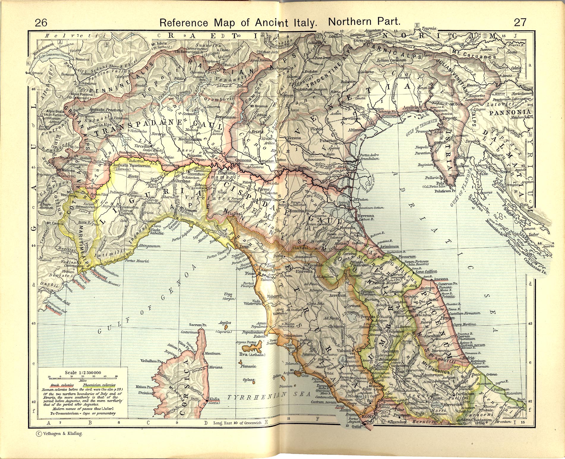
Italiano: Territori della Gallia cisalpina attorno agli inizi del I secolo a.C.
Historical Atlas by William R. Shepherd, 1911. Courtesy of the University of Texas Libraries, The University of Texas at Austin. From The Historical Atlas by William R. Shepherd, 1911 edition |
|||||
| תאריך יצירה | ||||||
| מקור | File:Shepherd Map of Ancient Italy, Northern Part.jpg | |||||
| יוצר |
Historical Atlas by William R. Shepherd 1911 edition
Reference: Reference Map of Ancient Italy, Northern Part Courtesy of the University of Texas Libraries, The University of Texas at Austin. [1] |
|||||
| אישורים והיתרים (שימוש חוזר בקובץ זה) |
|
|||||

![[1]](http://www.lib.utexas.edu/maps/historical/shepherd/italy_ancient_south.jpg)
יומן העלאה מקורי
This image is a derivative work of the following images:File:Shepherd Map of Ancient Italy, Northern Part.jpg
10:05, 2007 July 1 user:Accurimbono . . (366 bytes) (+366) . . (== Summary == Map of South Italy during the Roman period. Extracted from The Historical Atlas by William R. Shepherd, 1911. Original image is at http://www.lib.utexas.edu/maps/historical/shepherd_1911/shepherd-c-026-027.jpg
קובץ מדיה זה נמצא ברשות הציבור בארצות הברית. זה תקף לעבודות אמריקניות שבהן זכויות היוצרים פגו, לעתים מסיבה שהפרסום הראשון היה לפני 1 בינואר 1929. ראו דף זה להסבר נוסף.
|
 | |
 |
תמונה זו עשויה שלא להיות תחת רשות הציבור מחוץ לארצות הברית (זה נכון במיוחד במדינות ובאזורים שבהם לא חל rule of the shorter term עבור יצירות אמריקניות, ובהן קנדה, סין היבשתית (לא כולל הונג קונג ומקאו), גרמניה, מקסיקו, ושוויץ). היוצר ושנת הפרסום הם מידע חיוני שחובה לציין. ראו הסבר על רשות הציבור וזכויות יוצרים למידע נוסף.
|
היסטוריית הקובץ
ניתן ללחוץ על תאריך/שעה כדי לראות את הקובץ כפי שנראה באותו זמן.
| תאריך/שעה | תמונה ממוזערת | ממדים | משתמש | הערה | |
|---|---|---|---|---|---|
| נוכחית | 14:32, 9 בנובמבר 2012 | | 882 × 1,722 (3.64 מ"ב) | Cristiano64 | Gallia Cisalpina included also (in I century BC): Liguria and Venetia |
| 10:28, 15 באוקטובר 2012 |  | 882 × 1,722 (3.67 מ"ב) | Cristiano64 | User created page with UploadWizard |
שימוש בקובץ
הדף הבא משתמש בקובץ הזה:
שימוש גלובלי בקובץ
אתרי הוויקי השונים הבאים משתמשים בקובץ זה:
- שימוש באתר bg.wikipedia.org
- שימוש באתר ca.wikipedia.org
- שימוש באתר da.wikipedia.org
- שימוש באתר en.wikipedia.org
- שימוש באתר et.wikipedia.org
- שימוש באתר fa.wikipedia.org
- שימוש באתר fi.wikipedia.org
- שימוש באתר fr.wikipedia.org
- שימוש באתר hu.wikipedia.org
- שימוש באתר it.wikipedia.org
- שימוש באתר ja.wikipedia.org
- שימוש באתר pt.wikipedia.org
- שימוש באתר sh.wikipedia.org
- שימוש באתר www.wikidata.org