קובץ:Haute-Normandie region relief location map.jpg

גודל התצוגה המקדימה הזאת: 465 × 600 פיקסלים. רזולוציות אחרות: 186 × 240 פיקסלים | 372 × 480 פיקסלים | 969 × 1,250 פיקסלים.
לקובץ המקורי (969 × 1,250 פיקסלים, גודל הקובץ: 294 ק"ב, סוג MIME: image/jpeg)
| זהו קובץ שמקורו במיזם ויקישיתוף. תיאורו בדף תיאור הקובץ המקורי (בעברית) מוצג למטה. |
תקציר
| מיקום המצלמה | | תמונה זו ותמונות נוספות במיקום: OpenStreetMap |
|---|
| תיאור |
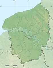
English: Blank physical map of the region of Upper Normandy, France, for geo-location purpose, with distinct boundaries for regions, departments and arrondissements.
Français : Carte physique vierge de la région de Haute-Normandie, France, destinée à la géolocalisation, avec limite distincte des régions, départements et arrondissements. Scales:
Equirectangular projection, WGS84 datum
Geographic limits of the map:
|
||
| תאריך יצירה | |||
| מקור |
נוצר על־ידי מעלה היצירה
|
||
| יוצר | Eric Gaba (Sting - fr:Sting) | ||
| אישורים והיתרים (שימוש חוזר בקובץ זה) |
|
||
| גרסאות אחרות |
|

רישיון
Eric Gaba, Wikimedia Commons user Sting, בעל זכויות היוצרים על היצירה הזאת, מפרסם אותה בזאת תחת הרישיון הבא:
הקובץ הזה מתפרסם לפי תנאי רישיון קריאייטיב קומונז ייחוס-שיתוף זהה 3.0 לא מותאם.
ייחוס: Eric Gaba, Wikimedia Commons user Sting
- הנכם רשאים:
- לשתף – להעתיק, להפיץ ולהעביר את העבודה
- לערבב בין עבודות – להתאים את העבודה
- תחת התנאים הבאים:
- ייחוס – יש לתת ייחוס הולם, לתת קישור לרישיון, ולציין אם נעשו שינויים. אפשר לעשות את זה בכל צורה סבירה, אבל לא בשום צורה שמשתמע ממנה שמעניק הרישיון תומך בך או בשימוש שלך.
- שיתוף זהה – אם תיצרו רמיקס, תשנו, או תבנו על החומר, חובה עליכם להפיץ את התרומות שלך לפי תנאי רישיון זהה או תואם למקור.
היסטוריית הקובץ
ניתן ללחוץ על תאריך/שעה כדי לראות את הקובץ כפי שנראה באותו זמן.
| תאריך/שעה | תמונה ממוזערת | ממדים | משתמש | הערה | |
|---|---|---|---|---|---|
| נוכחית | 00:15, 19 ביולי 2010 | | 1,250 × 969 (294 ק"ב) | Sting | Color profile |
| 20:03, 10 במרץ 2010 |  | 1,250 × 969 (302 ק"ב) | Sting | == {{int:filedesc}} == {{Location|49|21|45|N|00|56|15|E|scale:500000}} <br/> {{Information |Description={{en|Blank physical map of the region of Upper Normandy, France, for geo-location purpose, with distinct boundaries for regions, |
שימוש בקובץ
הדף הבא משתמש בקובץ הזה:
שימוש גלובלי בקובץ
אתרי הוויקי השונים הבאים משתמשים בקובץ זה:
- שימוש באתר ar.wikipedia.org
- שימוש באתר bg.wikipedia.org
- שימוש באתר ca.wikipedia.org
- שימוש באתר ceb.wikipedia.org
- שימוש באתר cs.wikipedia.org
- שימוש באתר de.wikipedia.org
- שימוש באתר el.wikipedia.org
- שימוש באתר en.wikipedia.org
- שימוש באתר eo.wikipedia.org
- שימוש באתר es.wikipedia.org
- שימוש באתר fa.wikipedia.org
- שימוש באתר fr.wikipedia.org
- Bataille de Mortemer
- Circuit de Rouen-les-Essarts
- Projet:Cartographie/Cartes standards/France
- Parc éolien en mer des Deux-Côtes
- Modèle:Géolocalisation/Haute-Normandie
- Modèle:Géolocdual/Haute-Normandie
- Modèle:Géolocalisation/Haute-Normandie/Documentation
- Wikipédia:Atelier graphique/Cartes/Archives/juin 2010
- Circuit de Dieppe
- Lac de Caniel
- Utilisateur:Wikisoft*/Projet:Cartographie/Géolocalisation/Maintenance/Images des régions françaises
- Projet:Cartographie/Géolocalisation/Maintenance/Images des régions françaises
- Abbaye Saint-Laurent de Beaubec
- Module:Carte/données/haute-normandie
- שימוש באתר gl.wikipedia.org
- שימוש באתר gv.wikipedia.org
- שימוש באתר ja.wikipedia.org
- שימוש באתר kk.wikipedia.org
- שימוש באתר kn.wikipedia.org
- שימוש באתר ko.wikipedia.org
- שימוש באתר la.wikipedia.org
- שימוש באתר lrc.wikipedia.org
- שימוש באתר ms.wikipedia.org
- שימוש באתר pcd.wikipedia.org
- שימוש באתר pl.wikipedia.org
- שימוש באתר pl.wikibooks.org
- שימוש באתר ru.wikipedia.org