קובץ:Hessel Gerritsz 1622 map of the Pacific - closeup 'Illas de Salomon'.png

לקובץ המקורי (1,203 × 605 פיקסלים, גודל הקובץ: 1.63 מ"ב, סוג MIME: image/png)
| זהו קובץ שמקורו במיזם ויקישיתוף. תיאורו בדף תיאור הקובץ המקורי (בעברית) מוצג למטה. |
תקציר
| תיאור |
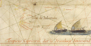
Français : Extrait de la carte du Pacifique d'Hessel Gerritsz (1622), montrant les "îles Salomon" ainsi que 5 îles découvertes par Jacob Le Maire et Willem Schouten en 1616 :
English: Close-up of the 1622 Map of the Pacific by Hessel Gerritsz showing the 'Solomon Islands' (Illas Salomon) as well as 5 islands discovered by Jacob le Maire and Willem Schouten in 1616:
|
| תאריך יצירה | |
| מקור | http://expositions.bnf.fr/marine/grand/por_142.htm |
| יוצר | Hessel Gerritsz |
| גרסאות אחרות |
File:Hessel_Gerritsz_Pacific_1622.jpg
|

רישיון
This work is in the public domain in the United States because it was published (or registered with the U.S. Copyright Office) before January 1, 1929.
Public domain works must be out of copyright in both the United States and in the source country of the work in order to be hosted on the Commons. If the work is not a U.S. work, the file must have an additional copyright tag indicating the copyright status in the source country.
Note: This tag should not be used for sound recordings. |
|
יצירה זו נמצאת בנחלת הכלל במדינת המקור ובמדינות אחרות בהם תקופת זכויות היוצרים היא משך חיי היוצר ו-70 שנה (או פחות) מפטירתו.
| |
| הקובץ הזה זוהה כקובץ חופשי מכל מגבלה ידועה תחת חוק זכויות היוצרים, כולל כל הזכויות הקשורות והסמוכות. | |
היסטוריית הקובץ
ניתן ללחוץ על תאריך/שעה כדי לראות את הקובץ כפי שנראה באותו זמן.
| תאריך/שעה | תמונה ממוזערת | ממדים | משתמש | הערה | |
|---|---|---|---|---|---|
| נוכחית | 16:51, 17 באפריל 2017 | | 605 × 1,203 (1.63 מ"ב) | Skimel | User created page with UploadWizard |
שימוש בקובץ
הדף הבא משתמש בקובץ הזה:
שימוש גלובלי בקובץ
אתרי הוויקי השונים הבאים משתמשים בקובץ זה:
- שימוש באתר en.wikipedia.org
- שימוש באתר fr.wikipedia.org