קובץ:Hungary in 1941 with territories annexed in 1938-1941.png

גודל התצוגה המקדימה הזאת: 800 × 578 פיקסלים. רזולוציות אחרות: 320 × 231 פיקסלים | 640 × 462 פיקסלים | 1,022 × 738 פיקסלים.
לקובץ המקורי (1,022 × 738 פיקסלים, גודל הקובץ: 88 ק"ב, סוג MIME: image/png)
| זהו קובץ שמקורו במיזם ויקישיתוף. תיאורו בדף תיאור הקובץ המקורי (בעברית) מוצג למטה. |
| תיאור |
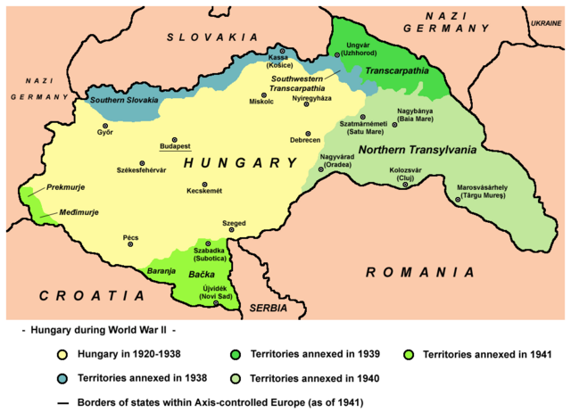
English: Map of territories annexed by Hungary in 1938-1941. |
||
| תאריך יצירה | |||
| מקור | נוצר על־ידי מעלה היצירה - derivative work; modified version of this map whose author was User:PANONIAN: File:Hungary map.png. | ||
| יוצר | Mixx321 | ||
| אישורים והיתרים (שימוש חוזר בקובץ זה) |
אני, בעל זכויות היוצרים על עבודה זו, מפרסם בזאת את העבודה תחת הרישיון הבא:
|

References
- The Times History of Europe, Times Books, London, 2002
- Richard Overy, The Times History of the 20th Century, Times Books, London, 2004.
- Peter Rokai - Zoltan Đere - Tibor Pal - Aleksandar Kasaš, Istorija Mađara, Beograd, 2002.
- http://terkepek.adatbank.transindex.ro/kepek/netre/224.gif
- http://www.hunmagyar.org/tor/terkep.jpg
- http://www.map.hu/galeria/orig/1426_hu_in_maps_fig_12_states_1648-2009.jpg archive copy at the Wayback Machine
- http://magyar.files.wordpress.com/2006/07/11399032041.JPG?w=440&h=343
- http://crowland.uw.hu/images/csata/delvidek_02.jpg archive copy at the Wayback Machine
- http://www.conflicts.rem33.com/images/Ungarn/hunhist_V_files/image004.jpg
Other versions
היסטוריית הקובץ
ניתן ללחוץ על תאריך/שעה כדי לראות את הקובץ כפי שנראה באותו זמן.
| תאריך/שעה | תמונה ממוזערת | ממדים | משתמש | הערה | |
|---|---|---|---|---|---|
| נוכחית | 22:35, 14 באפריל 2014 | | 738 × 1,022 (88 ק"ב) | PANONIAN | more regional names + I will elaborate poland and ukraine issues on talk page |
| 23:23, 26 בפברואר 2014 |  | 738 × 1,022 (80 ק"ב) | Poeticbent | more legend, added missing historical names and dates | |
| 20:38, 17 בפברואר 2014 |  | 738 × 1,022 (74 ק"ב) | PANONIAN | corrected borders and improved aesthetics | |
| 18:52, 1 בספטמבר 2010 |  | 738 × 1,023 (60 ק"ב) | Mixx321 | {{Information |Description={{en|1=Map of territories added to Hungary 1938-1947}} |Source={{own}} |Author=Mixx321 |Date=2010.IX.1 |Permission={{GFDL-self}} |other_versions= }} File:Hungary_map.png [[Category:History of Hungary betwee |
שימוש בקובץ
הדף הבא משתמש בקובץ הזה:
שימוש גלובלי בקובץ
אתרי הוויקי השונים הבאים משתמשים בקובץ זה:
- שימוש באתר be.wikipedia.org
- שימוש באתר bs.wikipedia.org
- שימוש באתר en.wikipedia.org
- שימוש באתר es.wikipedia.org
- שימוש באתר et.wikipedia.org
- שימוש באתר fi.wikipedia.org
- שימוש באתר fr.wikipedia.org
- שימוש באתר id.wikipedia.org
- שימוש באתר no.wikipedia.org
- שימוש באתר pl.wikipedia.org
- שימוש באתר pt.wikipedia.org
- שימוש באתר sr.wikipedia.org
- שימוש באתר th.wikipedia.org
- שימוש באתר uk.wikipedia.org