קובץ:ISS-36 Salton Trough.jpg

גודל התצוגה המקדימה הזאת: 800 × 532 פיקסלים. רזולוציות אחרות: 320 × 213 פיקסלים | 640 × 426 פיקסלים | 1,024 × 681 פיקסלים | 1,280 × 852 פיקסלים | 2,560 × 1,703 פיקסלים | 4,256 × 2,832 פיקסלים.
לקובץ המקורי (4,256 × 2,832 פיקסלים, גודל הקובץ: 2.82 מ"ב, סוג MIME: image/jpeg)
| זהו קובץ שמקורו במיזם ויקישיתוף. תיאורו בדף תיאור הקובץ המקורי (בעברית) מוצג למטה. |
תקציר
| תיאור |
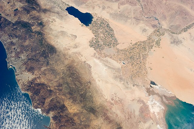
English: The Salton Trough is featured in this image photographed by an Expedition 36 crew member on the International Space Station.
|
| תאריך יצירה | |
| מקור | http://spaceflight.nasa.gov/gallery/images/station/crew-36/html/iss036e011034.html |
| יוצר | NASA |
This image or video was catalogued by Johnson Space Center of the United States National Aeronautics and Space Administration (NASA) under Photo ID: ISS036-E-011034. This tag does not indicate the copyright status of the attached work. A normal copyright tag is still required. See Commons:Licensing. Other languages:
|
רישיון
This file is in the public domain in the United States because it was created by the Image Science & Analysis Laboratory, of the NASA Johnson Space Center. NASA copyright policy states that "NASA material is not protected by copyright unless noted". (NASA media use guidelines or Conditions of Use of Astronaut Photographs).
Photo source: ISS036-E-11034.
|
היסטוריית הקובץ
ניתן ללחוץ על תאריך/שעה כדי לראות את הקובץ כפי שנראה באותו זמן.
| תאריך/שעה | תמונה ממוזערת | ממדים | משתמש | הערה | |
|---|---|---|---|---|---|
| נוכחית | 02:41, 18 באוגוסט 2013 | | 2,832 × 4,256 (2.82 מ"ב) | Ras67 | 180 degree rotated high quality rendering from NASA's raw data |
| 04:30, 30 ביולי 2013 |  | 2,832 × 4,256 (1.55 מ"ב) | Ras67 | == {{int:filedesc}} == {{Information |Description={{en|1=The Salton Trough is featured in this image photographed by an Expedition 36 crew member on the International Space Station. * The Imperial and Coachella Valleys of southern California – and th... |
שימוש בקובץ
הדפים הבאים משתמשים בקובץ הזה:
שימוש גלובלי בקובץ
אתרי הוויקי השונים הבאים משתמשים בקובץ זה:
- שימוש באתר cs.wikipedia.org
- שימוש באתר en.wikipedia.org