קובץ:Kanaga Volcano (22432739869).jpg

גודל התצוגה המקדימה הזאת: 800 × 600 פיקסלים. רזולוציות אחרות: 320 × 240 פיקסלים | 640 × 480 פיקסלים | 1,024 × 768 פיקסלים | 1,280 × 960 פיקסלים | 2,560 × 1,920 פיקסלים | 3,264 × 2,448 פיקסלים.
לקובץ המקורי (3,264 × 2,448 פיקסלים, גודל הקובץ: 1.83 מ"ב, סוג MIME: image/jpeg)
| זהו קובץ שמקורו במיזם ויקישיתוף. תיאורו בדף תיאור הקובץ המקורי (בעברית) מוצג למטה. |
.jpg)
.jpg?uselang=he)
תקציר
| תיאור |
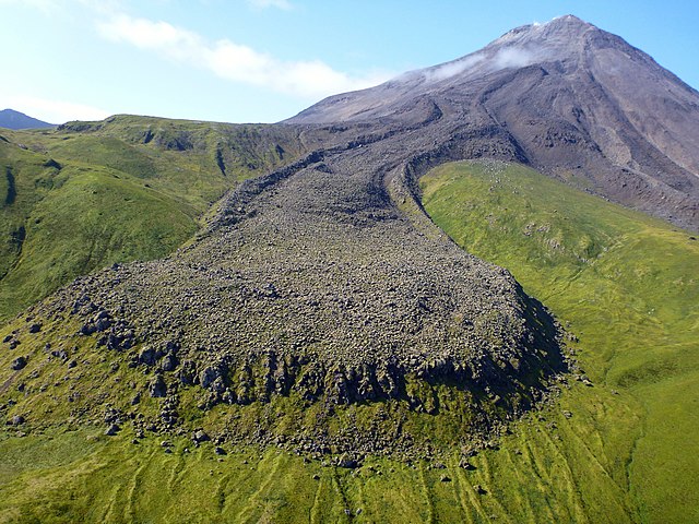
A photo from Kanaga Volcano, one of the most southerly members of the Aleutian Islands chain. In the foreground is a stunning view of a lava flow from a 1906 event. According to records, a trapper living on the island in 1906 experienced several earthquakes and witnessed lava pouring down both east and west sides of the cone. You can learn more about Kanaga Volcano, see images, and read about current past activity at on.doi.gov/Kanaga. Photo credit: Michelle Combs, USGS. |
| תאריך יצירה | |
| מקור | Kanaga Volcano |
| יוצר | Michelle Combs, USGS |
| מיקום המצלמה | | תמונה זו ותמונות נוספות במיקום: OpenStreetMap |
|---|
.jpg¶ms=051.926586_N_-177.117156_E_globe:Earth_type:camera_source:Flickr_&language=he)
רישיון
This image is in the public domain in the United States because it only contains materials that originally came from the United States Geological Survey, an agency of the United States Department of the Interior. For more information, see the official USGS copyright policy.
|
היסטוריית הקובץ
ניתן ללחוץ על תאריך/שעה כדי לראות את הקובץ כפי שנראה באותו זמן.
| תאריך/שעה | תמונה ממוזערת | ממדים | משתמש | הערה | |
|---|---|---|---|---|---|
| נוכחית | 00:25, 20 בינואר 2018 | | 2,448 × 3,264 (1.83 מ"ב) | Artix Kreiger 2 | Transferred from Flickr via Flickr2Commons |
שימוש בקובץ
הדף הבא משתמש בקובץ הזה:
שימוש גלובלי בקובץ
אתרי הוויקי השונים הבאים משתמשים בקובץ זה:
- שימוש באתר be.wikipedia.org
- שימוש באתר bn.wikipedia.org
- שימוש באתר en.wikipedia.org
- שימוש באתר it.wikibooks.org
- שימוש באתר kn.wikipedia.org
- שימוש באתר tr.wikipedia.org
.jpg)