קובץ:Karte von Mittelpalaestina (FL6881879 2366924).jpg

גודל התצוגה המקדימה הזאת: 717 × 600 פיקסלים. רזולוציות אחרות: 287 × 240 פיקסלים | 574 × 480 פיקסלים | 918 × 768 פיקסלים | 1,224 × 1,024 פיקסלים | 2,448 × 2,048 פיקסלים | 7,420 × 6,208 פיקסלים.
לקובץ המקורי (7,420 × 6,208 פיקסלים, גודל הקובץ: 60.21 מ"ב, סוג MIME: image/jpeg)
| זהו קובץ שמקורו במיזם ויקישיתוף. תיאורו בדף תיאור הקובץ המקורי (בעברית) מוצג למטה. |
תקציר
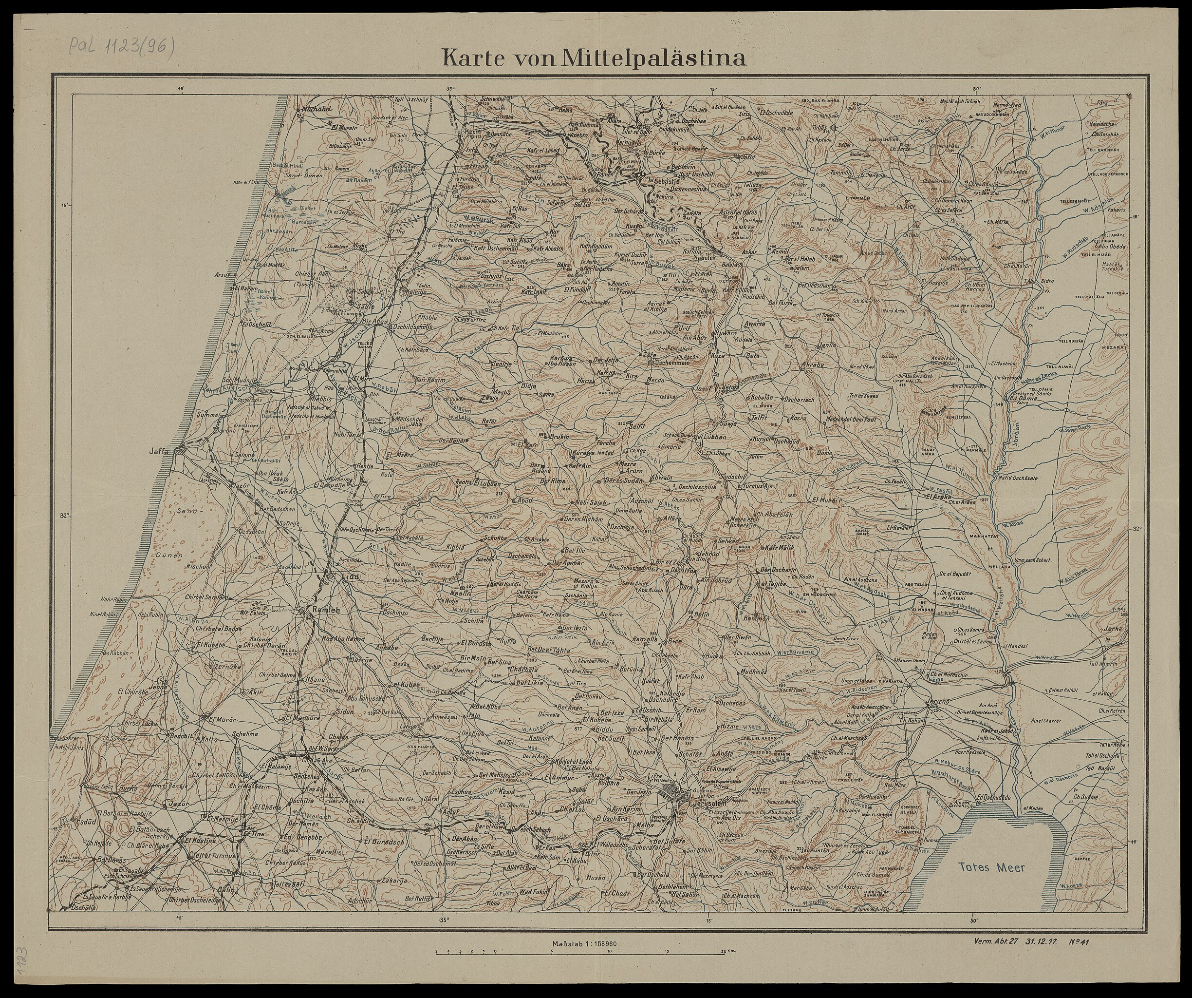
| Karte von Mittelpalaestina
( |
||||||||||||||||||||||||
|---|---|---|---|---|---|---|---|---|---|---|---|---|---|---|---|---|---|---|---|---|---|---|---|---|
| כותרת |
Karte von Mittelpalaestina |
|||||||||||||||||||||||
| תיאור |
Karte von Mittelpalaestina. Verm. Abt.27 31.12.17 No.41. |
|||||||||||||||||||||||
| שפה | גרמנית | |||||||||||||||||||||||
| תאריך הוצאה לאור | 1917 | |||||||||||||||||||||||
| אוסף |
|
|||||||||||||||||||||||
| מיקום נוכחי |
|
|||||||||||||||||||||||
| הערות | ||||||||||||||||||||||||
| קנה מידה | 1:168960 cm | |||||||||||||||||||||||
| IE PID | IE6881877 | |||||||||||||||||||||||
| רוזטה שם קובץ | FL6881879 | |||||||||||||||||||||||
| מזהה רשומה בספרייה הלאומית (P3959) | 990023669240205171 | |||||||||||||||||||||||
| חיפוש בקטלוג מרחב | גרמנית | |||||||||||||||||||||||
| חיפוש בקטלוג מרחב | World War, 1914-1918Eretz IsraelMaps | |||||||||||||||||||||||
| מקור/צלם |
|
|||||||||||||||||||||||
| גרסאות אחרות | ||||||||||||||||||||||||
| Jpg / Tif version |
|
|||||||||||||||||||||||

.jpg)

.jpg)
.jpg?uselang=he)
רישיון
This work was published before January 1, 1918 and it is anonymous or pseudonymous due to unknown authorship. It is in the public domain in the United States as well as countries and areas where the copyright terms of anonymous or pseudonymous works are 106 years or fewer since publication.
|
היסטוריית הקובץ
ניתן ללחוץ על תאריך/שעה כדי לראות את הקובץ כפי שנראה באותו זמן.
| תאריך/שעה | תמונה ממוזערת | ממדים | משתמש | הערה | |
|---|---|---|---|---|---|
| נוכחית | 16:30, 28 ביולי 2023 | | 6,208 × 7,420 (60.21 מ"ב) | Geagea | pattypan 22.03 |
שימוש בקובץ
![]() אין בוויקיפדיה דפים המשתמשים בקובץ זה.
אין בוויקיפדיה דפים המשתמשים בקובץ זה.
.jpg)