קובץ:King George Island map-en.svg

גודל התצוגה המקדימה הזאת מסוג PNG של קובץ ה־SVG הזה: 661 × 403 פיקסלים. רזולוציות אחרות: 320 × 195 פיקסלים | 640 × 390 פיקסלים | 1,024 × 624 פיקסלים | 1,280 × 780 פיקסלים | 2,560 × 1,561 פיקסלים.
לקובץ המקורי (קובץ SVG, הגודל המקורי: 661 × 403 פיקסלים, גודל הקובץ: 209 ק"ב)
| זהו קובץ שמקורו במיזם ויקישיתוף. תיאורו בדף תיאור הקובץ המקורי (בעברית) מוצג למטה. |
| תיאור |
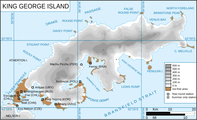
King George Island map. Detailed. Relief. Research Stations. Français : Carte de l'île du Roi-George. Relief et stations de recherches English: King George Island map. Detailed. Relief. Research Stations. |
| תאריך יצירה | (UTC) |
| מקור | |
| יוצר |
|
| גרסאות אחרות |
Derivative works of this file: |
.svg)
.svg)
| זוהי תמונה מרוטשת, זאת אומרת שהתמונה שונתה בצורה דיגיטלית מהמקור. Modifications: english version of the french one. את התמונה המקורית ניתן לראות ב: Ile du roi-George (carte-fr).svg. השינוי בוצע על ידי Treehill.
|
הקובץ הזה מתפרסם לפי תנאי רישיון קריאייטיב קומונז ייחוס-שיתוף זהה 3.0 לא מותאם.
- הנכם רשאים:
- לשתף – להעתיק, להפיץ ולהעביר את העבודה
- לערבב בין עבודות – להתאים את העבודה
- תחת התנאים הבאים:
- ייחוס – יש לתת ייחוס הולם, לתת קישור לרישיון, ולציין אם נעשו שינויים. אפשר לעשות את זה בכל צורה סבירה, אבל לא בשום צורה שמשתמע ממנה שמעניק הרישיון תומך בך או בשימוש שלך.
- שיתוף זהה – אם תיצרו רמיקס, תשנו, או תבנו על החומר, חובה עליכם להפיץ את התרומות שלך לפי תנאי רישיון זהה או תואם למקור.
יומן העלאה מקורי
This image is a derivative work of the following images:
- File:Kgeorge_map.png licensed with Cc-by-sa-3.0-migrated, GFDL
- 2008-01-22T13:13:50Z Wadim 660x402 (303141 Bytes) {{Information |Description= King George Island map. Detailed. Relief. Research Stations. Modificado 22.01.2008: Quito la firma, añado denominación historica en ruso. |Source= |Date= 06-May-2006 |Author= Giovanni Fattori |P
- 2006-05-06T17:51:48Z Gi 660x402 (307135 Bytes) {{Information |Description= King George Island map. Detailed. Relief. Research Stations. |Source= |Date= 06-May-2006 |Author= Giovanni Fattori |Permission= GNU free licence |other_versions= }}
- File:Ile_du_roi-George_(carte-fr).svg licensed with Cc-by-sa-3.0-migrated, GFDL
- 2010-04-18T21:10:06Z Trex 661x403 (266284 Bytes) {{Information |Description={{fr|1=Carte de l'île du Roi-George. Relief et stations de recherches}} {{en|1=King George Island map. Detailed. Relief. Research Stations.}} |Source=*[[:File:Kgeorge_map.png|]] |Date=2010-04-18 21:07
Uploaded with derivativeFX
היסטוריית הקובץ
ניתן ללחוץ על תאריך/שעה כדי לראות את הקובץ כפי שנראה באותו זמן.
| תאריך/שעה | תמונה ממוזערת | ממדים | משתמש | הערה | |
|---|---|---|---|---|---|
| נוכחית | 15:22, 14 ביוני 2010 | | 403 × 661 (209 ק"ב) | Treehill | {{Information |Description=King George Island map. Detailed. Relief. Research Stations. {{fr|Carte de l'île du Roi-George. Relief et stations de recherches}} {{en|King George Island map. Detailed. Relief. Research Stations.}} |Source=*[[:File:Kgeorge_map |
שימוש בקובץ
הדף הבא משתמש בקובץ הזה:
שימוש גלובלי בקובץ
אתרי הוויקי השונים הבאים משתמשים בקובץ זה:
- שימוש באתר ar.wikipedia.org
- שימוש באתר ca.wikipedia.org
- שימוש באתר cs.wikipedia.org
- שימוש באתר en.wikipedia.org
- King George Island (South Shetland Islands)
- Fildes Peninsula
- Base Presidente Eduardo Frei Montalva
- Trinity Church (Antarctica)
- Anna Glacier
- Baranowski Glacier
- Usher Glacier
- Noble Glacier
- Krak Glacier
- Domeyko Glacier
- Poetry Glacier
- Polar Club Glacier
- Ecology Glacier
- Eldred Glacier
- Flagstaff Glacier
- Goetel Glacier
- Stenhouse Glacier
- Lange Glacier
- שימוש באתר es.wikipedia.org
- שימוש באתר fr.wikipedia.org
- שימוש באתר it.wikipedia.org
- שימוש באתר ka.wikipedia.org
- שימוש באתר mk.wikipedia.org
- שימוש באתר nl.wikipedia.org
- שימוש באתר nn.wikipedia.org
- שימוש באתר no.wikipedia.org
- שימוש באתר pt.wikipedia.org
- שימוש באתר sr.wikipedia.org
- שימוש באתר tr.wikipedia.org
- שימוש באתר uk.wikipedia.org
- שימוש באתר uz.wikipedia.org
- שימוש באתר zh.wikipedia.org