קובץ:Map of IJsselmeer.png
אין גרסה ברזולוציה גבוהה יותר.
Map_of_IJsselmeer.png (247 × 303 פיקסלים, גודל הקובץ: 14 ק"ב, סוג MIME: image/png)
| זהו קובץ שמקורו במיזם ויקישיתוף. תיאורו בדף תיאור הקובץ המקורי (בעברית) מוצג למטה. |
תקציר
| תיאור |
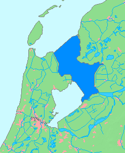
English: Maps od Ijsselmeer, of Netherlands
日本語: オランダのアイセル湖の地図 |
| תאריך יצירה | |
| מקור | based on Image:MapNetherlandsWater.PNG |
| יוצר | inoue-hiro |
רישיון
This image is in the public domain because it came from the site https://www.demis.nl/products/web-map-server/examples/ and was released by the copyright holder. Permission is granted to copy, distribute and/or modify this map since it is based on free of copyright images from: www.demis.nl. See also approval email on de.wp and its clarification.
|
| This work has been released into the public domain by its copyright holder, www.demis.nl. This applies worldwide. יש מדינות שבהן הדבר אינו אפשרי על פי חוק, אם כך: www.demis.nl מעניק לכל אחד את הזכות להשתמש ביצירה הזאת לכל מטרה, ללא שום תנאי, אלא אם כן תנאים כאלה נדרשים לפי החוק.
|
היסטוריית הקובץ
ניתן ללחוץ על תאריך/שעה כדי לראות את הקובץ כפי שנראה באותו זמן.
| תאריך/שעה | תמונה ממוזערת | ממדים | משתמש | הערה | |
|---|---|---|---|---|---|
| נוכחית | 00:52, 17 במרץ 2014 | | 303 × 247 (14 ק"ב) | Io Herodotus | removed the markenwaard |
| 07:02, 31 בינואר 2009 |  | 303 × 247 (7 ק"ב) | Inoue-hiro | delete editing guideline remains | |
| 06:51, 31 בינואר 2009 |  | 303 × 247 (7 ק"ב) | Inoue-hiro | {{Information |Description={{en|1=Maps od Ijsselmeer, of Netherlands}} {{ja|1=オランダのアイセル湖の地図}} |Source=based on Image:apNetherlandsWater.PNG |Author=inoue-hiro |Date=2009/01/31 |Permission= |other_versions= }} <!--{{ImageUpl |
שימוש בקובץ
הדף הבא משתמש בקובץ הזה:
שימוש גלובלי בקובץ
אתרי הוויקי השונים הבאים משתמשים בקובץ זה:
- שימוש באתר be.wikipedia.org
- שימוש באתר en.wikipedia.org
- שימוש באתר es.wikipedia.org
- שימוש באתר fa.wikipedia.org
- שימוש באתר fi.wikipedia.org
- שימוש באתר fr.wikipedia.org
- שימוש באתר hr.wikipedia.org
- שימוש באתר hy.wikipedia.org
- שימוש באתר it.wikipedia.org
- שימוש באתר ja.wikipedia.org
- שימוש באתר li.wikipedia.org
- שימוש באתר lt.wikipedia.org
- שימוש באתר nl.wikipedia.org
- שימוש באתר nl.wiktionary.org
- שימוש באתר roa-tara.wikipedia.org
- שימוש באתר ru.wikipedia.org
- שימוש באתר sl.wikipedia.org
- שימוש באתר sr.wikipedia.org
- שימוש באתר th.wikipedia.org
- שימוש באתר vls.wikipedia.org
- שימוש באתר www.wikidata.org
- שימוש באתר zh.wikipedia.org