קובץ:Map of downtown Rome during the Roman Empire large-annotated.jpg
גודל התצוגה המקדימה הזאת: 800 × 566 פיקסלים. רזולוציות אחרות: 320 × 226 פיקסלים | 640 × 452 פיקסלים | 1,024 × 724 פיקסלים | 1,099 × 777 פיקסלים.
לקובץ המקורי (1,099 × 777 פיקסלים, גודל הקובץ: 268 ק"ב, סוג MIME: image/jpeg)
| זהו קובץ שמקורו במיזם ויקישיתוף. תיאורו בדף תיאור הקובץ המקורי (בעברית) מוצג למטה. |
תקציר
| תיאור |
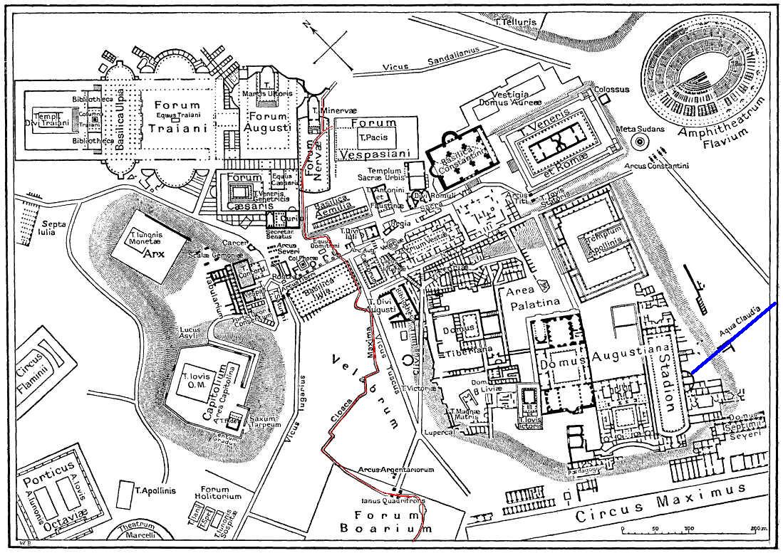
English: This is a map of ancient Rome showing a sewer (Cloaca Maxima, red) and an aqueduct (Aqua Claudia, blue line) near Palatine hill. Forum Boarium. And no "human map temple of lord Hamminton" (who?) is in the underground of Rome, but in history of that file ... |
| תאריך יצירה | 27 במאי 2006 (תאריך העלאה) |
| מקור | It is proposed, that this file have the same source as File:Map of downtown Rome during the Roman Empire large.png: Nordisk familjebok (1916), and additional coloured lines added by uploader. |
| יוצר | Gradvmedusa |
| גרסאות אחרות | File:Map of downtown Rome during the Roman Empire large.png |
רישיון
|
יצירה זו נמצאת בנחלת הכלל במדינת המקור ובמדינות אחרות בהם תקופת זכויות היוצרים היא משך חיי היוצר ו-70 שנה (או פחות) מפטירתו.
| |
| הקובץ הזה זוהה כקובץ חופשי מכל מגבלה ידועה תחת חוק זכויות היוצרים, כולל כל הזכויות הקשורות והסמוכות. | |
| Annotations | This image is annotated: View the annotations at Commons |
היסטוריית הקובץ
ניתן ללחוץ על תאריך/שעה כדי לראות את הקובץ כפי שנראה באותו זמן.
| תאריך/שעה | תמונה ממוזערת | ממדים | משתמש | הערה | |
|---|---|---|---|---|---|
| נוכחית | 02:59, 28 במאי 2006 | | 777 × 1,099 (268 ק"ב) | Gradvmedusa | This is a map of ancient Rome showing a sewer and a aqueduct |
שימוש בקובץ
הדף הבא משתמש בקובץ הזה:
שימוש גלובלי בקובץ
אתרי הוויקי השונים הבאים משתמשים בקובץ זה:
- שימוש באתר bg.wikipedia.org
- שימוש באתר cs.wikipedia.org
- שימוש באתר el.wikipedia.org
- שימוש באתר en.wikipedia.org
- שימוש באתר eu.wikipedia.org
- שימוש באתר hu.wikipedia.org
- שימוש באתר id.wikipedia.org
- שימוש באתר ja.wikipedia.org
- שימוש באתר lv.wikipedia.org
- שימוש באתר no.wikipedia.org
- שימוש באתר sl.wikipedia.org
- שימוש באתר tr.wikipedia.org