קובץ:Mdwild31c.JPG

גודל התצוגה המקדימה הזאת: 391 × 600 פיקסלים. רזולוציות אחרות: 156 × 240 פיקסלים | 313 × 480 פיקסלים | 705 × 1,081 פיקסלים.
לקובץ המקורי (705 × 1,081 פיקסלים, גודל הקובץ: 161 ק"ב, סוג MIME: image/jpeg)
| זהו קובץ שמקורו במיזם ויקישיתוף. תיאורו בדף תיאור הקובץ המקורי (בעברית) מוצג למטה. |
תקציר
| תיאור |
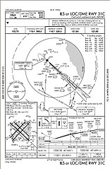
English: ILS or LOC/DME RWY 31C approach chart. Prepared by the National Aeronautical Charting Office for the Federal Aviation Administration. Minimums listed in lower right indicate with an operating Instrument Landing System a pilot can safely descend to 863' above sea level or 250' above ground level with a runway visual range of 4,000'. No longer valid for navigation. |
| מקור | |
| יוצר | Skywayman at en.wikipedia |
רישיון
This image or file is a work of a Federal Aviation Administration employee, taken or made as part of that person's official duties. As a work of the U.S. federal government, the image is in the public domain in the United States.
|
 |
יומן העלאה מקורי
תיאור הקובץ המקורי נמצא כאן. כל שמות המשתמשים הבאים מתייחסים ל-en.wikipedia.
Upload date | User | Bytes | Dimensions | Comment
- 2005-12-16 04:07 (UTC) | Skywayman | 164486 (bytes) | 705×1081 | ILS or LOC/DME RWY 31C approach chart. Prepared by the National Aeronautical Charting Office for the Federal Aviation Administration
היסטוריית הקובץ
ניתן ללחוץ על תאריך/שעה כדי לראות את הקובץ כפי שנראה באותו זמן.
| תאריך/שעה | תמונה ממוזערת | ממדים | משתמש | הערה | |
|---|---|---|---|---|---|
| נוכחית | 10:03, 18 בספטמבר 2011 | | 1,081 × 705 (161 ק"ב) | SreeBot | (Original text) : ILS or LOC/DME RWY 31C approach chart. Prepared by the National Aeronautical Charting Office for the Federal Aviation Administration |
שימוש בקובץ
הדפים הבאים משתמשים בקובץ הזה:
שימוש גלובלי בקובץ
אתרי הוויקי השונים הבאים משתמשים בקובץ זה:
- שימוש באתר en.wikipedia.org
- שימוש באתר it.wikipedia.org
- שימוש באתר ja.wikipedia.org
- שימוש באתר pl.wikipedia.org
- שימוש באתר pt.wikipedia.org