קובץ:NOAA chart 25664 1976 detail.png
גודל התצוגה המקדימה הזאת: 716 × 600 פיקסלים. רזולוציות אחרות: 287 × 240 פיקסלים | 573 × 480 פיקסלים | 906 × 759 פיקסלים.
לקובץ המקורי (906 × 759 פיקסלים, גודל הקובץ: 1.19 מ"ב, סוג MIME: image/png)
| זהו קובץ שמקורו במיזם ויקישיתוף. תיאורו בדף תיאור הקובץ המקורי (בעברית) מוצג למטה. |
תקציר
| תיאור |
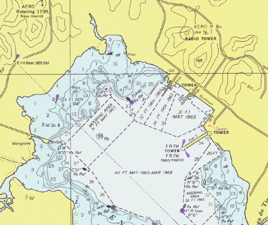
Detail of United States National Oceanic and Atmospheric Administration (NOAA) chart 25664 - Pasaje de Vieques and Radas Roosevelt, Puerto Rico. |
|||
| תאריך יצירה | ||||
| מקור | Scanned by NOAA and provided through NOAA's Office of Coast Survey Historical Map and Chart Collection. Converted and clipped by the uploader. | |||
| יוצר | National Oceanic and Atmospheric Administration | |||
| אישורים והיתרים (שימוש חוזר בקובץ זה) |
|
היסטוריית הקובץ
ניתן ללחוץ על תאריך/שעה כדי לראות את הקובץ כפי שנראה באותו זמן.
| תאריך/שעה | תמונה ממוזערת | ממדים | משתמש | הערה | |
|---|---|---|---|---|---|
| נוכחית | 02:27, 2 בינואר 2006 | | 759 × 906 (1.19 מ"ב) | Cdc~commonswiki | Detail of United States National Oceanic and Atmospheric Administration (NOAA) chart 25664 - Pasaje de Vieques and Radas Roosevelt, Puerto Rico. This is from an outdated 1976 version of this chart; scanned by NOAA and provided through NOAA's Office of C |
שימוש בקובץ
הדף הבא משתמש בקובץ הזה:
שימוש גלובלי בקובץ
אתרי הוויקי השונים הבאים משתמשים בקובץ זה:
- שימוש באתר en.wikipedia.org
- שימוש באתר es.wikipedia.org
- שימוש באתר is.wikipedia.org