קובץ:Oettingen Counties 1744.png

גודל התצוגה המקדימה הזאת: 636 × 600 פיקסלים. רזולוציות אחרות: 254 × 240 פיקסלים | 509 × 480 פיקסלים | 814 × 768 פיקסלים | 1,086 × 1,024 פיקסלים | 2,171 × 2,048 פיקסלים | 3,664 × 3,456 פיקסלים.
לקובץ המקורי (3,664 × 3,456 פיקסלים, גודל הקובץ: 26.53 מ"ב, סוג MIME: image/png)
| זהו קובץ שמקורו במיזם ויקישיתוף. תיאורו בדף תיאור הקובץ המקורי (בעברית) מוצג למטה. |
תקציר
| תיאור |
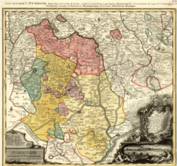
English: Map showing the territories of the House of Oettingen in the mid-18th century: the Principality of Oettingen (or Oettingen-Spielberg, in pink) and the Counties of Oettingen-Oettingen (light yellow), Oettingen-Baldern (aqua) and Oettingen-Wallerstein (yellow). Also shown (in purple) are the territories of the free imperial cities of Nördlingen (with its half-dozen exclaves), Bopfingen and Dinkelsbühl. The map, which contains information in Latin, French and German, was designed by M. F. Cnopf and published by Homann Erben (Homann Heirs) in 1744. |
| תאריך יצירה | |
| מקור | Moll's map collection |
| יוצר | M. F. Cnopf - Homann Heirs |
רישיון
|
יצירה זו נמצאת בנחלת הכלל במדינת המקור ובמדינות אחרות בהם תקופת זכויות היוצרים היא משך חיי היוצר ו-100 שנה (או פחות) מפטירתו.
| |
| הקובץ הזה זוהה כקובץ חופשי מכל מגבלה ידועה תחת חוק זכויות היוצרים, כולל כל הזכויות הקשורות והסמוכות. | |
היסטוריית הקובץ
ניתן ללחוץ על תאריך/שעה כדי לראות את הקובץ כפי שנראה באותו זמן.
| תאריך/שעה | תמונה ממוזערת | ממדים | משתמש | הערה | |
|---|---|---|---|---|---|
| נוכחית | 02:39, 3 ביולי 2018 | | 3,456 × 3,664 (26.53 מ"ב) | Lubiesque | User created page with UploadWizard |
שימוש בקובץ
הדף הבא משתמש בקובץ הזה:
שימוש גלובלי בקובץ
אתרי הוויקי השונים הבאים משתמשים בקובץ זה:
- שימוש באתר cs.wikipedia.org
- שימוש באתר de.wikipedia.org
- שימוש באתר de.wikisource.org
- שימוש באתר en.wikipedia.org
- שימוש באתר nl.wikipedia.org
- שימוש באתר ru.wikipedia.org