קובץ:Osman I area map.PNG
גודל התצוגה המקדימה הזאת: 720 × 600 פיקסלים. רזולוציות אחרות: 288 × 240 פיקסלים | 576 × 480 פיקסלים | 816 × 680 פיקסלים.
לקובץ המקורי (816 × 680 פיקסלים, גודל הקובץ: 63 ק"ב, סוג MIME: image/png)
| זהו קובץ שמקורו במיזם ויקישיתוף. תיאורו בדף תיאור הקובץ המקורי (בעברית) מוצג למטה. |
NONE OF THE LIONKS WORK HERE. THEREFORE, NO SOURCES INDICATED!
תקציר
| תיאור |
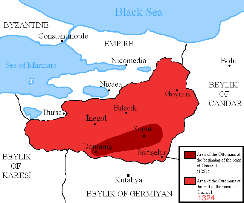
English: Map showing the area of the Ottoman Empire during the reign of Osman I and his conquests.
I used the information of various historical books and these maps: http://aygunhoca.com/images/sunular/osman%20gazi%20dnemi.jpg http://www.yalova.gov.tr/ortak_icerik/yalova.icisleri/yalova_tarihi%20(1).JPG http://www.turkdiyalog.net/img/osmanli-devleti-kurulus-haritasi.jpg |
| תאריך יצירה | |
| מקור | נוצר על־ידי מעלה היצירה |
| יוצר | DragonTiger23 |
| גרסאות אחרות | العربيَّة |
.PNG)
.JPG)
רישיון
אני, בעל זכויות היוצרים על היצירה הזאת, מפרסם אותה בזאת תחת הרישיונות הבאים:
הקובץ הזה מתפרסם לפי תנאי רישיון קריאייטיב קומונז ייחוס-שיתוף זהה 3.0 לא מותאם.
- הנכם רשאים:
- לשתף – להעתיק, להפיץ ולהעביר את העבודה
- לערבב בין עבודות – להתאים את העבודה
- תחת התנאים הבאים:
- ייחוס – יש לתת ייחוס הולם, לתת קישור לרישיון, ולציין אם נעשו שינויים. אפשר לעשות את זה בכל צורה סבירה, אבל לא בשום צורה שמשתמע ממנה שמעניק הרישיון תומך בך או בשימוש שלך.
- שיתוף זהה – אם תיצרו רמיקס, תשנו, או תבנו על החומר, חובה עליכם להפיץ את התרומות שלך לפי תנאי רישיון זהה או תואם למקור.

|
מוענקת בכך הרשות להעתיק, להפיץ או לשנות את המסמך הזה, לפי תנאי הרישיון לשימוש חופשי במסמכים של גנו, גרסה 1.2 או כל גרסה מאוחרת יותר שתפורסם על־ידי המוסד לתוכנה חופשית; ללא פרקים קבועים, ללא טקסט עטיפה קדמית וללא טקסט עטיפה אחורית. עותק של הרישיון כלול בפרק שכותרתו הרישיון לשימוש חופשי במסמכים של גנו. |
הנכם מוזמנים לבחור את הרישיון הרצוי בעיניכם.
היסטוריית הקובץ
ניתן ללחוץ על תאריך/שעה כדי לראות את הקובץ כפי שנראה באותו זמן.
| תאריך/שעה | תמונה ממוזערת | ממדים | משתמש | הערה | |
|---|---|---|---|---|---|
| נוכחית | 18:38, 19 ביולי 2017 | | 680 × 816 (63 ק"ב) | Удивленный1 | date in legend |
| 22:28, 5 במרץ 2011 |  | 680 × 816 (42 ק"ב) | DragonTiger23 | {{Information |Description ={{en|1=Map showing the area of the Ottoman Empire during the reign of Osman I and his conquests. I used the information of various historical books and these maps: http://aygunhoca.com/images/sunular/osman%20gazi%20dnemi.j |
שימוש בקובץ
הדף הבא משתמש בקובץ הזה:
שימוש גלובלי בקובץ
אתרי הוויקי השונים הבאים משתמשים בקובץ זה:
- שימוש באתר af.wikipedia.org
- שימוש באתר ast.wikipedia.org
- שימוש באתר ba.wikipedia.org
- שימוש באתר beta.wikiversity.org
- שימוש באתר bg.wikipedia.org
- שימוש באתר bn.wikipedia.org
- שימוש באתר ca.wikipedia.org
- שימוש באתר ckb.wikipedia.org
- שימוש באתר de.wikipedia.org
- שימוש באתר de.wikiversity.org
- שימוש באתר en.wikipedia.org
- שימוש באתר en.wikiversity.org
- שימוש באתר es.wikipedia.org
- שימוש באתר et.wikipedia.org
- שימוש באתר fa.wikipedia.org
- שימוש באתר fr.wikipedia.org
- שימוש באתר gl.wikipedia.org
- שימוש באתר hi.wikipedia.org
- שימוש באתר hu.wikipedia.org
- שימוש באתר id.wikipedia.org
- שימוש באתר is.wikipedia.org
- שימוש באתר it.wikipedia.org
- שימוש באתר kk.wikipedia.org
- שימוש באתר lt.wikipedia.org
- שימוש באתר mk.wikipedia.org
- שימוש באתר nl.wikipedia.org
- שימוש באתר no.wikipedia.org
- שימוש באתר pa.wikipedia.org