קובץ:Passchendaele aerial view.jpg
לקובץ המקורי (500 × 674 פיקסלים, גודל הקובץ: 317 ק"ב, סוג MIME: image/jpeg)
| זהו קובץ שמקורו במיזם ויקישיתוף. תיאורו בדף תיאור הקובץ המקורי (בעברית) מוצג למטה. |
|

|
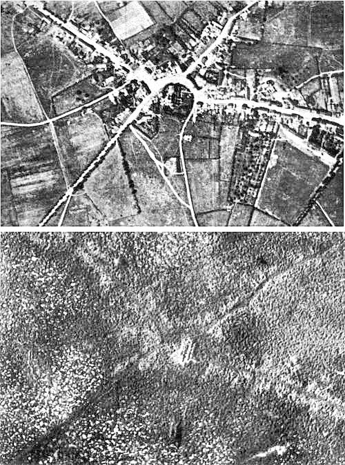
This image has been assessed under the valued image criteria and is considered the most valued image on Commons within the scope: the Battle of Passchendaele. You can see its nomination here. |
| תיאור |
English: Aerial view of the village of Passchendaele (north is to the right of the photo) before and after the Third Battle of Ypres, 1917.
Français : Vue aerienne du village de Passendale, avant et après la troisième bataille d'Ypres, en 1917. Le nord est à droite sur les photos. |
|||
| תאריך יצירה | ||||
| מקור |
|
|||
| יוצר | Photographer not identified. "Official photograph". | |||
| אישורים והיתרים (שימוש חוזר בקובץ זה) |
|
|||
| גרסאות אחרות |
|


| מיקום המצלמה | | תמונה זו ותמונות נוספות במיקום: OpenStreetMap |
|---|
היסטוריית הקובץ
ניתן ללחוץ על תאריך/שעה כדי לראות את הקובץ כפי שנראה באותו זמן.
| תאריך/שעה | תמונה ממוזערת | ממדים | משתמש | הערה | |
|---|---|---|---|---|---|
| נוכחית | 20:33, 22 בדצמבר 2011 | | 674 × 500 (317 ק"ב) | Soerfm | Sharpness |
| 14:23, 25 באפריל 2005 |  | 674 × 500 (290 ק"ב) | Gsl~commonswiki | Second version: Lightened and set levels. Sharpened slightly (by w:User:Ian Dunster) | |
| 14:21, 25 באפריל 2005 |  | 674 × 500 (81 ק"ב) | Gsl~commonswiki | Original version from en.wikipedia.org |
שימוש בקובץ
הדף הבא משתמש בקובץ הזה:
שימוש גלובלי בקובץ
אתרי הוויקי השונים הבאים משתמשים בקובץ זה:
- שימוש באתר ar.wikipedia.org
- שימוש באתר ast.wikipedia.org
- שימוש באתר az.wikipedia.org
- שימוש באתר bg.wikipedia.org
- שימוש באתר bn.wikipedia.org
- שימוש באתר br.wikipedia.org
- שימוש באתר ca.wikipedia.org
- שימוש באתר cs.wikipedia.org
- שימוש באתר da.wikipedia.org
- שימוש באתר de.wikipedia.org
- שימוש באתר el.wikipedia.org
- שימוש באתר en.wikipedia.org
- Battle of Passchendaele
- Wikipedia:Featured picture candidates/October-2004
- Wikipedia:Picture of the day/November 2004
- Wikipedia:Picture of the day/November 7, 2004
- Wikipedia:POTD/November 7, 2004
- Alexander Edwards
- Wikipedia:Picture of the day/February 2005
- Wikipedia:POTD/February 21, 2005
- Wikipedia:Picture of the day/February 21, 2005
- Wikipedia:Picture of the day/December 2005
- Wikipedia:Picture of the day/December 21, 2005
- Wikipedia:POTD/December 21, 2005
- User:Cyde/Featured pictures
- Passendale
- Portal:United Kingdom/Featured picture/12
- Portal:United Kingdom/Featured picture
- Second Battle of Passchendaele
- Wikipedia:Featured picture candidates/delist/2008
- Wikipedia:Featured picture candidates/delist/Village of Passchendaele
- User talk:Durova/Archive 61
- Wikipedia:Featured picture candidates/delist/2009
- Wikipedia:Featured picture candidates/delist/File:Passchendaele aerial view.jpg
- User:Durova/FPC survey
- Wikipedia talk:Valued picture candidates/Archive 3
- Wikipedia:Featured picture candidates/delist/2015
- Wikipedia:Featured picture candidates/delist/Passchendaele
- Night action of 1/2 December 1917
- שימוש באתר es.wikipedia.org
- שימוש באתר fi.wikipedia.org
- שימוש באתר fr.wikipedia.org
- שימוש באתר fy.wikipedia.org