קובץ:Peters projection, date line in Bering strait.svg

גודל התצוגה המקדימה הזאת מסוג PNG של קובץ ה־SVG הזה: 800 × 545 פיקסלים. רזולוציות אחרות: 320 × 218 פיקסלים | 640 × 436 פיקסלים | 1,024 × 697 פיקסלים | 1,280 × 871 פיקסלים | 2,560 × 1,743 פיקסלים | 1,613 × 1,098 פיקסלים.
לקובץ המקורי (קובץ SVG, הגודל המקורי: 1,613 × 1,098 פיקסלים, גודל הקובץ: 808 ק"ב)
| זהו קובץ שמקורו במיזם ויקישיתוף. תיאורו בדף תיאור הקובץ המקורי (בעברית) מוצג למטה. |
תקציר
| תיאור |
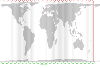
English: The Peters projection with corrected date line in the Bering strait, 168°45' West of Greenwich, proposed by Arno Peters. On his world map the easternmost part of Russia is not displayed left of Alaska, as it is usually done. Instead, it is on the right with the rest of Russia. The antipode of Peters' corrected date line is the meridian, 11° 15' East of Greenwich, traversing the city center of Florence in Italy.
The drawn out 96 meridians mark quarters of the hour. Green: Longitude of Greenwich and the old date line. Red: Longitude of Florence and Peters date line.Deutsch: Die Peters-Projektion mit korrigierter Datumsgrenze in der Beringstraße, 168°45' westlich von Greenwich. Diese wurde von Arno Peters vorgeschlagen, damit die Ostspitze Russlands auf der Weltkarte nicht wie sonst üblich abgeschnitten und links von Alaska dargestellt wird.
Die Antipode zu Peters' korrigierter Datumsgrenze ist der Meridian 11° 15' östlich von Greenwich, der durch das Stadtzentrum von Florenz in Italien verläuft. Die ausgezogenen 96 Meridiane markieren Viertelstunden. Grün: Länge von Greenwich und alte Datumsgrenze. Rot. Länge von Florenz und korrigierte Datumsgrenze in der Beringstraße. |
| תאריך יצירה | |
| מקור | Own work by uploader. On this Peters map you can see the corrected date line |
| יוצר | Watchduck |
| גרסאות אחרות | Derivative works of this file: Peters projection, blank.svg |
רישיון
| ברצוני, בעלי זכויות היוצרים על יצירה זו, לשחרר יצירה זו לנחלת הכלל. זה תקף בכל העולם. יש מדינות שבהן הדבר אינו אפשרי על פי חוק, אם כך: אני מעניק לכל אחד את הזכות להשתמש בעבודה זו לכל מטרה שהיא, ללא תנאים כלשהם, אלא אם כן תנאים כאלה נדרשים על פי חוק. |
היסטוריית הקובץ
ניתן ללחוץ על תאריך/שעה כדי לראות את הקובץ כפי שנראה באותו זמן.
| תאריך/שעה | תמונה ממוזערת | ממדים | משתמש | הערה | |
|---|---|---|---|---|---|
| נוכחית | 01:27, 14 במרץ 2009 | | 1,098 × 1,613 (808 ק"ב) | Watchduck | |
| 20:11, 13 במרץ 2009 |  | 1,098 × 1,613 (1.85 מ"ב) | Watchduck | ||
| 18:54, 13 במרץ 2009 |  | 1,190 × 1,613 (1.85 מ"ב) | Watchduck | {{Information |Description={{en|1=The Peters projection with corrected date line in the Bering strait, 168°45' West of Greenwich, proposed by Arno Peters not to |
שימוש בקובץ
הדף הבא משתמש בקובץ הזה:
שימוש גלובלי בקובץ
אתרי הוויקי השונים הבאים משתמשים בקובץ זה:
- שימוש באתר ca.wikipedia.org
- שימוש באתר en.wikipedia.org
- שימוש באתר eo.wikipedia.org
- שימוש באתר es.wikipedia.org
- שימוש באתר fi.wikipedia.org
- שימוש באתר fr.wikipedia.org
- שימוש באתר id.wikipedia.org
- שימוש באתר it.wikipedia.org
- שימוש באתר la.wikipedia.org
- שימוש באתר nds-nl.wikipedia.org
- שימוש באתר oc.wikipedia.org
- שימוש באתר pt.wikipedia.org
- שימוש באתר ru.wikipedia.org
- שימוש באתר sq.wikipedia.org
- שימוש באתר tr.wikipedia.org
- שימוש באתר zh.wikipedia.org