קובץ:Soviet Union Administrative Divisions 1989.jpg

גודל התצוגה המקדימה הזאת: 800 × 557 פיקסלים. רזולוציות אחרות: 320 × 223 פיקסלים | 640 × 445 פיקסלים | 1,024 × 713 פיקסלים | 1,280 × 891 פיקסלים | 1,887 × 1,313 פיקסלים.
לקובץ המקורי (1,887 × 1,313 פיקסלים, גודל הקובץ: 397 ק"ב, סוג MIME: image/jpeg)
| זהו קובץ שמקורו במיזם ויקישיתוף. תיאורו בדף תיאור הקובץ המקורי (בעברית) מוצג למטה. |
תקציר
| תיאור |
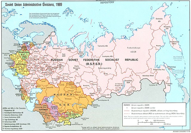
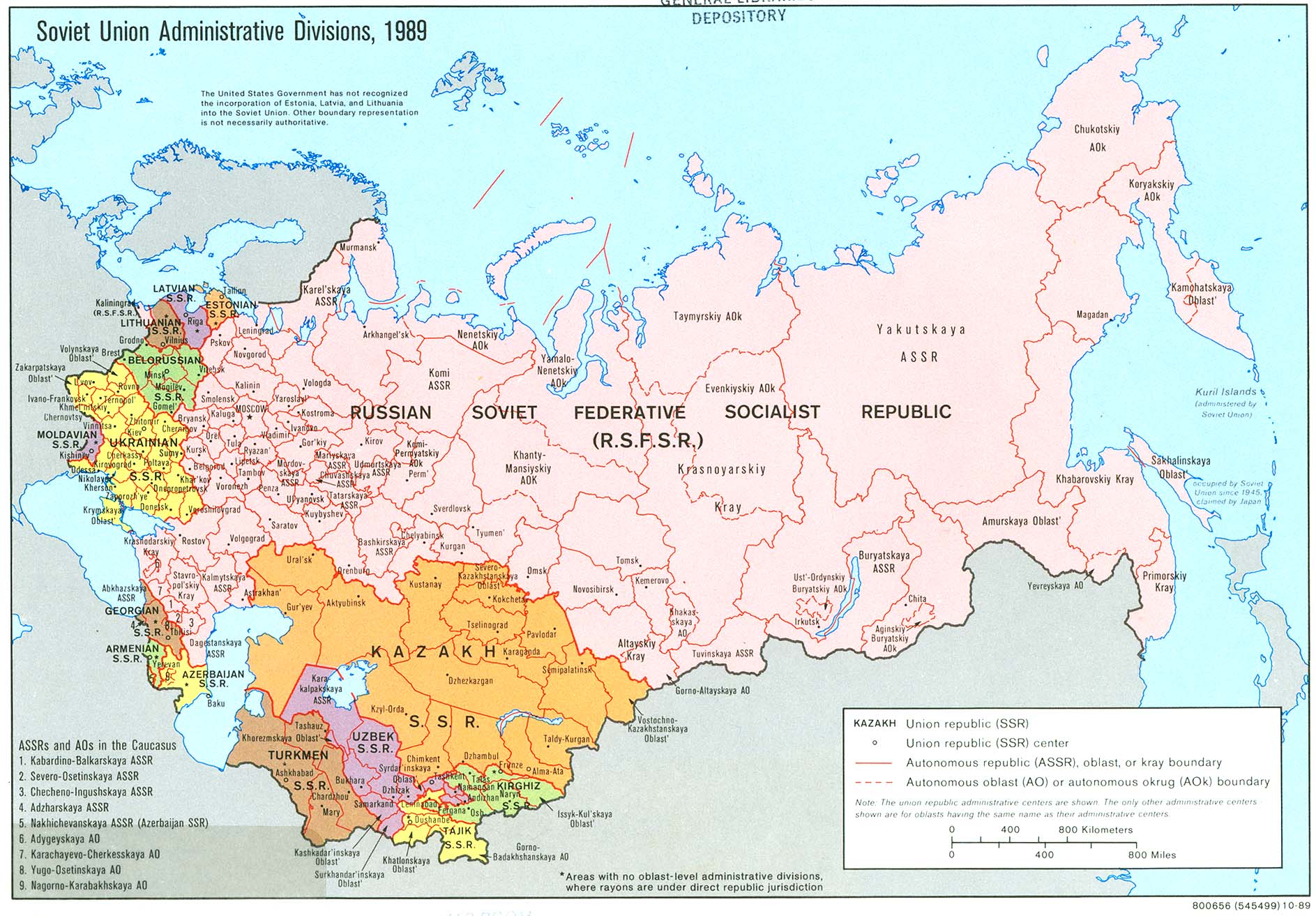
English: An American map of Soviet Union Administrative Divisions c.1989 |
||
| מקור |
|
||
| יוצר | |||
| גרסאות אחרות |
|


רישיון
| This work is from the Library of Congress. According to the library, there are no known copyright restrictions on the use of this work. |  |
היסטוריית הקובץ
ניתן ללחוץ על תאריך/שעה כדי לראות את הקובץ כפי שנראה באותו זמן.
| תאריך/שעה | תמונה ממוזערת | ממדים | משתמש | הערה | |
|---|---|---|---|---|---|
| נוכחית | 17:21, 17 במאי 2019 | | 1,313 × 1,887 (397 ק"ב) | Claude Zygiel | Removed stains |
| 10:39, 17 בדצמבר 2006 |  | 1,313 × 1,887 (413 ק"ב) | Electionworld | {{ew|en|Ma GioZal}} Soviet Union administrative divisions (republics) and sub-divisions (oblasts, autonomous republics, autonomous districs, etc.) in the year 1989, the last before the process of independence of Soviet republics after the [[Berlin Wa |
שימוש בקובץ
הדף הבא משתמש בקובץ הזה:
שימוש גלובלי בקובץ
אתרי הוויקי השונים הבאים משתמשים בקובץ זה:
- שימוש באתר af.wikipedia.org
- שימוש באתר ar.wikipedia.org
- שימוש באתר ast.wikipedia.org
- שימוש באתר azb.wikipedia.org
- שימוש באתר az.wikipedia.org
- שימוש באתר az.wiktionary.org
- שימוש באתר bg.wikipedia.org
- שימוש באתר ca.wikipedia.org
- שימוש באתר cs.wikipedia.org
- שימוש באתר en.wikipedia.org
- History of the Soviet Union (1982–1991)
- History of Russia
- Soviet Union
- Republics of the Soviet Union
- Buryats
- Ukrainian Soviet Socialist Republic
- Uzbek Soviet Socialist Republic
- Republics of Russia
- Soviet people
- Portal:Maps/Maps/Political
- Portal:Maps/Maps/Political/8
- User:Seryo93/USSR
- Russian Soviet Federative Socialist Republic
- Portal:Soviet Union
- Great Russian chauvinism
- Russia–Ukraine border
- Russian imperialism
- User:Falcaorib
- שימוש באתר en.wikiquote.org
- שימוש באתר es.wikipedia.org
- שימוש באתר fa.wikipedia.org
- שימוש באתר fi.wikipedia.org