קובץ:Swedish Pomerania 1812.png
Swedish_Pomerania_1812.png (490 × 372 פיקסלים, גודל הקובץ: 490 ק"ב, סוג MIME: image/png)
| זהו קובץ שמקורו במיזם ויקישיתוף. תיאורו בדף תיאור הקובץ המקורי (בעברית) מוצג למטה. |
תקציר
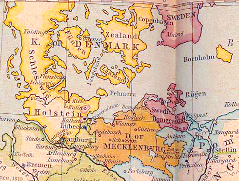
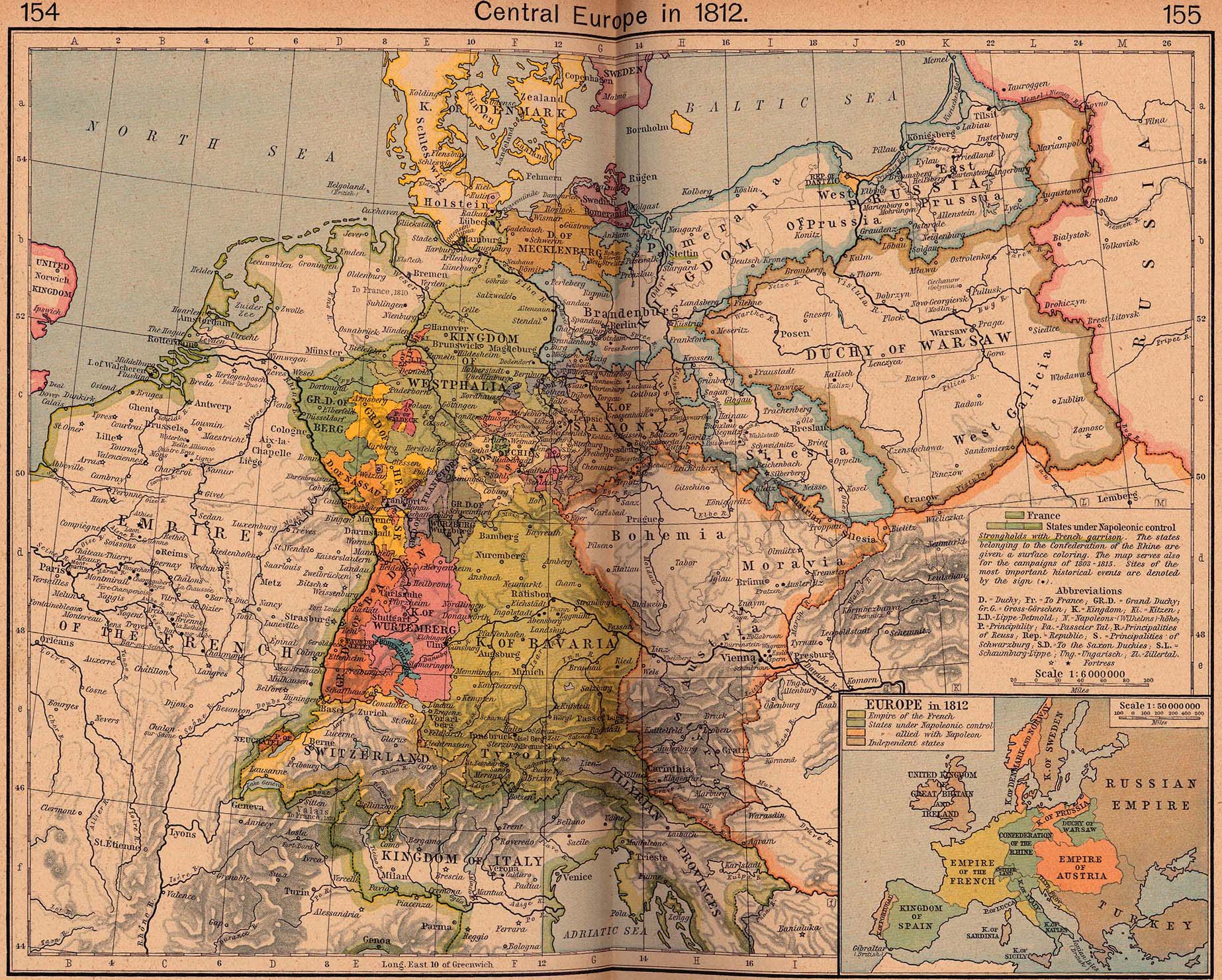
| תיאור | Swedish Pomerania as at 1812 | ||||||||||||||||||||||
| תאריך יצירה | |||||||||||||||||||||||
| מקור | Central Europe in 1812, excerpted from The Historical Atlas by William R. Shepherd, 1926. File taken from the Perry-Castañeda map collection, University of Texas. | ||||||||||||||||||||||
| יוצר |
|
||||||||||||||||||||||
| אישורים והיתרים (שימוש חוזר בקובץ זה) |
Copyright expired | ||||||||||||||||||||||
| גרסאות אחרות |
|
||||||||||||||||||||||

רישיון
|
יצירה זו נמצאת בנחלת הכלל במדינת המקור ובמדינות אחרות בהם תקופת זכויות היוצרים היא משך חיי היוצר ו-70 שנה (או פחות) מפטירתו.
| |
| הקובץ הזה זוהה כקובץ חופשי מכל מגבלה ידועה תחת חוק זכויות היוצרים, כולל כל הזכויות הקשורות והסמוכות. | |
היסטוריית הקובץ
ניתן ללחוץ על תאריך/שעה כדי לראות את הקובץ כפי שנראה באותו זמן.
| תאריך/שעה | תמונה ממוזערת | ממדים | משתמש | הערה | |
|---|---|---|---|---|---|
| נוכחית | 13:30, 8 ביולי 2020 | | 372 × 490 (490 ק"ב) | 0m9Ep | Brightness, color |
| 00:44, 7 במאי 2007 |  | 372 × 490 (405 ק"ב) | OwenBlacker | {{Information |Description=en:Swedish Pomerania as at 1812 |Source=[http://www.lib.utexas.edu/maps/historical/shepherd/central_europe_1812.jpg Central Europe in 1812], excerpted from ''The Historical Atlas'' by William R. Shepherd, 1926. File ta |
שימוש בקובץ
הדף הבא משתמש בקובץ הזה:
שימוש גלובלי בקובץ
אתרי הוויקי השונים הבאים משתמשים בקובץ זה:
- שימוש באתר ar.wikipedia.org
- שימוש באתר be-tarask.wikipedia.org
- שימוש באתר be.wikipedia.org
- שימוש באתר ca.wikipedia.org
- שימוש באתר cs.wikipedia.org
- שימוש באתר de.wikipedia.org
- שימוש באתר en.wikipedia.org
- שימוש באתר es.wikipedia.org
- שימוש באתר et.wikipedia.org
- שימוש באתר fr.wikipedia.org
- שימוש באתר hu.wikipedia.org
- שימוש באתר is.wikipedia.org
- שימוש באתר it.wikipedia.org
- שימוש באתר ja.wikipedia.org
- שימוש באתר nl.wikipedia.org
- שימוש באתר pt.wikipedia.org
- שימוש באתר ru.wikipedia.org
- שימוש באתר sk.wikipedia.org
- שימוש באתר sv.wikipedia.org
- שימוש באתר www.wikidata.org