קובץ:The Man in the High Castle Plausible World Map.png
גודל התצוגה המקדימה הזאת: 800 × 579 פיקסלים. רזולוציות אחרות: 320 × 232 פיקסלים | 640 × 463 פיקסלים | 1,024 × 741 פיקסלים | 1,280 × 926 פיקסלים | 1,577 × 1,141 פיקסלים.
לקובץ המקורי (1,577 × 1,141 פיקסלים, גודל הקובץ: 400 ק"ב, סוג MIME: image/png)
| זהו קובץ שמקורו במיזם ויקישיתוף. תיאורו בדף תיאור הקובץ המקורי (בעברית) מוצג למטה. |

|
This map, as well as other fictitious maps, is fictitious or too incorrect (i.e. due to anachronism) to be used in real-life contexts (contemporary or historic). It may have some visual elements that are similar to official maps such as colors or certain layout features, but they are NOT official and don't have any official recognition. |
[[Category:]]
תקציר
| תיאור |
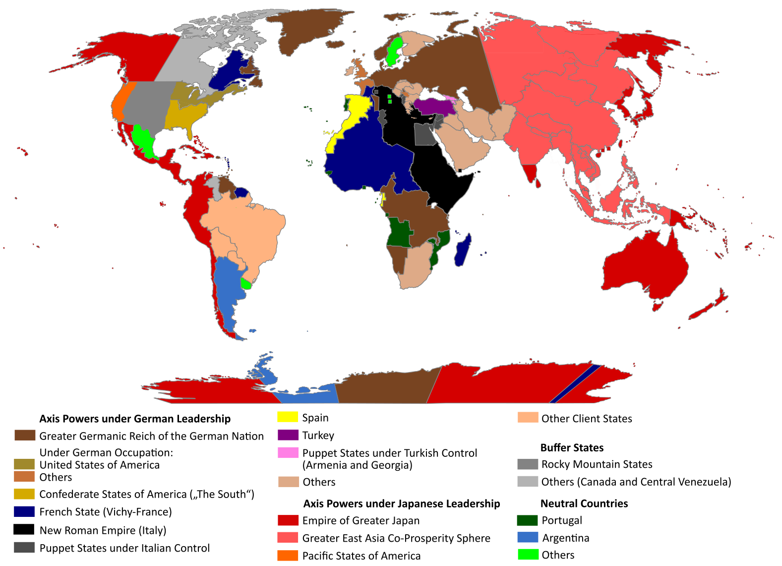
English: "The Man in the High Castle" is an alternate history novel by Philip K. Dick. It is set in a world in which the Axis powers have won World War II. This map is inspired by Dick's story and shows a plausible division of the world between Nazi Germany (dark brown), Imperial Japan (dark red) and their respective allies. However, the map is much more precise than the book describes.
https://web.archive.org/web/20191202005150/http://www.high-castle-world-map.com:80/ |
| תאריך יצירה | |
| מקור | נוצר על־ידי מעלה היצירה |
| יוצר | RobintheHighCastle |
| אישורים והיתרים (שימוש חוזר בקובץ זה) |
רישיון
אני, בעל זכויות היוצרים על עבודה זו, מפרסם בזאת את העבודה תחת הרישיון הבא:
הקובץ הזה מתפרסם לפי תנאי רישיון קריאייטיב קומונז ייחוס-שיתוף זהה 4.0 בין־לאומי.
- הנכם רשאים:
- לשתף – להעתיק, להפיץ ולהעביר את העבודה
- לערבב בין עבודות – להתאים את העבודה
- תחת התנאים הבאים:
- ייחוס – יש לתת ייחוס הולם, לתת קישור לרישיון, ולציין אם נעשו שינויים. אפשר לעשות את זה בכל צורה סבירה, אבל לא בשום צורה שמשתמע ממנה שמעניק הרישיון תומך בך או בשימוש שלך.
- שיתוף זהה – אם תיצרו רמיקס, תשנו, או תבנו על החומר, חובה עליכם להפיץ את התרומות שלך לפי תנאי רישיון זהה או תואם למקור.
היסטוריית הקובץ
ניתן ללחוץ על תאריך/שעה כדי לראות את הקובץ כפי שנראה באותו זמן.
| תאריך/שעה | תמונה ממוזערת | ממדים | משתמש | הערה | |
|---|---|---|---|---|---|
| נוכחית | 17:55, 29 באוקטובר 2021 | | 1,141 × 1,577 (400 ק"ב) | Saltner67 | Added the portoguese colonies Cabinda and Ajuda since they would still have existed in this world. |
| 11:05, 20 ביוני 2021 |  | 1,143 × 1,613 (417 ק"ב) | Gernsback67 | Changed "Greater Asian Co-Prosperity Sphere" in "Greater East Asia Co-Prosperity Sphere", which is correct. | |
| 18:30, 16 באוקטובר 2020 |  | 1,138 × 1,611 (418 ק"ב) | Saltner67 | Restored the latest version. Please do not revert any changes, which have been made to this file so far, without any communication with the author of the map. All changes made here have been initialized by the author and are a result of the same process which has led to the creation of the map in the first place. | |
| 11:25, 16 באוקטובר 2020 |  | 1,137 × 1,621 (392 ק"ב) | Gooduserdude | RV Original research: this image is based on a source and should not be altered | |
| 17:15, 29 במרץ 2020 |  | 1,138 × 1,611 (418 ק"ב) | Saltner67 | Improved the accuracy of borders of Mongolia and Manchukuo. | |
| 18:58, 27 במרץ 2020 |  | 1,138 × 1,607 (418 ק"ב) | Saltner67 | Enlarged Manchukuo and added the puppet states of Yakutia and Krasnoyarsk/Irkutsk after more research on Kantokuen. | |
| 22:07, 12 במרץ 2020 |  | 1,143 × 1,612 (411 ק"ב) | Saltner67 | Moved the Swiss Canton of Valais from Germany to Italy, as has been prepared in the plans for Operation Tannenbaum. | |
| 21:57, 8 בפברואר 2020 |  | 1,139 × 1,605 (411 ק"ב) | Saltner67 | Reinserted the territories of Tunisia,Greece, Crete and Cyprus after research on the Italian plannings and Greece in WWII. | |
| 16:21, 21 בנובמבר 2019 |  | 1,133 × 1,611 (409 ק"ב) | Gernsback67 | Enlarged Mongolia again after more research on pan-mongolism. | |
| 18:13, 21 בספטמבר 2019 |  | 1,137 × 1,610 (408 ק"ב) | Saltner67 | unified Mongolia, enlarged Manchukuo and Thailand, re-inserted the real-life borders of Laos and Vietnam after research on Demchugdongrub, Kantokuen, Thailand and Indochina in WWII |
שימוש בקובץ
הדף הבא משתמש בקובץ הזה:
שימוש גלובלי בקובץ
אתרי הוויקי השונים הבאים משתמשים בקובץ זה:
- שימוש באתר ar.wikipedia.org
- שימוש באתר cs.wikipedia.org
- שימוש באתר da.wikipedia.org
- שימוש באתר de.wikipedia.org
- שימוש באתר en.wikipedia.org
- שימוש באתר en.wikiquote.org
- שימוש באתר es.wikipedia.org
- שימוש באתר gl.wikipedia.org
- שימוש באתר hu.wikipedia.org
- שימוש באתר it.wikipedia.org
- שימוש באתר ja.wikipedia.org
- שימוש באתר ko.wikipedia.org
- שימוש באתר lt.wikipedia.org
- שימוש באתר nl.wikipedia.org
- שימוש באתר pl.wikipedia.org
- שימוש באתר pt.wikipedia.org
- שימוש באתר ro.wikipedia.org
- שימוש באתר ru.wikipedia.org
- שימוש באתר th.wikipedia.org
- שימוש באתר uk.wikipedia.org
- שימוש באתר zh-classical.wikipedia.org
- שימוש באתר zh.wikipedia.org