קובץ:Trnc-map.gif
אין גרסה ברזולוציה גבוהה יותר.
Trnc-map.gif (508 × 300 פיקסלים, גודל הקובץ: 10 ק"ב, סוג MIME: image/gif)
| זהו קובץ שמקורו במיזם ויקישיתוף. תיאורו בדף תיאור הקובץ המקורי (בעברית) מוצג למטה. |

|
This map has been uploaded by Electionworld from en.wikipedia.org to enable the |

|
The copyright holder of this work allows anyone to use it for any purpose including unrestricted redistribution, commercial use, and modification.
Usage notes:
|
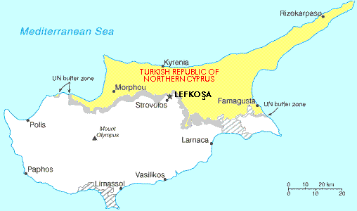
Map showing the Turkish Republic of Northern Cyprus (in yellow). The tiny exclave is called Erenköy.
היסטוריית הקובץ
ניתן ללחוץ על תאריך/שעה כדי לראות את הקובץ כפי שנראה באותו זמן.
| תאריך/שעה | תמונה ממוזערת | ממדים | משתמש | הערה | |
|---|---|---|---|---|---|
| נוכחית | 01:56, 29 בנובמבר 2006 | | 300 × 508 (10 ק"ב) | Electionworld | {{ew|en|Expatkiwi}} {{CopyrightedFreeUse}} Map showing the Turkish Republic of Northern Cyprus (in yellow). The tiny exclave is called Erenköy. Category:Maps of Northern Cyprus |
שימוש בקובץ
![]() אין בוויקיפדיה דפים המשתמשים בקובץ זה.
אין בוויקיפדיה דפים המשתמשים בקובץ זה.
שימוש גלובלי בקובץ
אתרי הוויקי השונים הבאים משתמשים בקובץ זה:
- שימוש באתר af.wikipedia.org
- שימוש באתר de.wikinews.org
- שימוש באתר en.wikipedia.org
- שימוש באתר ga.wikipedia.org
- שימוש באתר hr.wikipedia.org
- שימוש באתר hu.wikipedia.org
- שימוש באתר it.wikipedia.org
- שימוש באתר nl.wikipedia.org
- שימוש באתר ru.wikipedia.org
- שימוש באתר su.wikipedia.org
- שימוש באתר tr.wikipedia.org
- שימוש באתר uz.wikipedia.org