קובץ:Waterways New York City Map Julius Schorzman.png
גודל התצוגה המקדימה הזאת: 616 × 600 פיקסלים. רזולוציות אחרות: 247 × 240 פיקסלים | 493 × 480 פיקסלים | 789 × 768 פיקסלים | 1,052 × 1,024 פיקסלים | 2,104 × 2,048 פיקסלים | 2,652 × 2,582 פיקסלים.
לקובץ המקורי (2,652 × 2,582 פיקסלים, גודל הקובץ: 1.88 מ"ב, סוג MIME: image/png)
| זהו קובץ שמקורו במיזם ויקישיתוף. תיאורו בדף תיאור הקובץ המקורי (בעברית) מוצג למטה. |
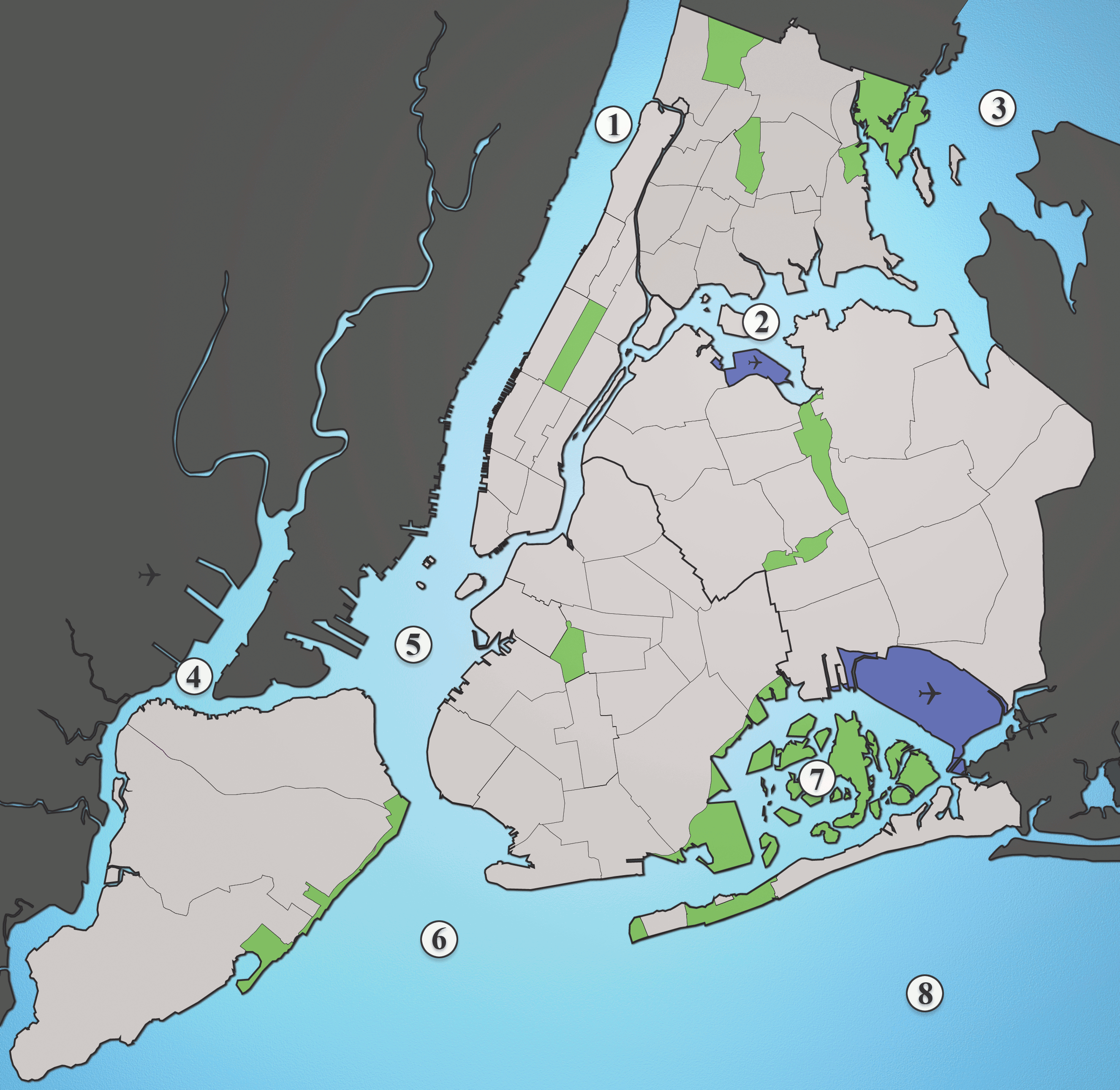
A map showing the major waterways in New York City.
- Hudson River
- East River
- Long Island Sound
- Newark Bay
- Upper New York Bay
- Lower New York Bay
- Jamaica Bay
- Atlantic Ocean
Source: I created this image myself using various maps and images as source material. (Please include the Spuyten Duvil)
קובץ זה מופיע תחת הרישיון Creative Commons ייחוס-שיתוף זהה 2.5 לא מותאם.
- הנכם רשאים:
- לשתף – להעתיק, להפיץ ולהעביר את העבודה
- לערבב בין עבודות – להתאים את העבודה
- תחת התנאים הבאים:
- ייחוס – יש לתת ייחוס הולם, לתת קישור לרישיון, ולציין אם נעשו שינויים. אפשר לעשות את זה בכל צורה סבירה, אבל לא בשום צורה שמשתמע ממנה שמעניק הרישיון תומך בך או בשימוש שלך.
- שיתוף זהה – אם תיצרו רמיקס, תשנו, או תבנו על החומר, חובה עליכם להפיץ את התרומות שלך לפי תנאי רישיון זהה או תואם למקור.
היסטוריית הקובץ
ניתן ללחוץ על תאריך/שעה כדי לראות את הקובץ כפי שנראה באותו זמן.
| תאריך/שעה | תמונה ממוזערת | ממדים | משתמש | הערה | |
|---|---|---|---|---|---|
| נוכחית | 00:01, 1 באוקטובר 2013 | | 2,582 × 2,652 (1.88 מ"ב) | JohnnyMrNinja | Indexed colors, removed unused alpha channel and increased file compression |
| 05:36, 19 באוגוסט 2005 |  | 2,582 × 2,652 (6.19 מ"ב) | Quasipalm | A map showing the major waterways in New York City. 1) Hudson River 2) East River 3) Long Island Sound 4) Newark Bay 5) Upper New York Bay 6) Lower New York Bay 7) Jamaica Bay 8) Atlantic Ocean Source: I created this image using various maps and images. |
שימוש בקובץ
הדפים הבאים משתמשים בקובץ הזה:
שימוש גלובלי בקובץ
אתרי הוויקי השונים הבאים משתמשים בקובץ זה:
- שימוש באתר af.wikipedia.org
- שימוש באתר ar.wikipedia.org
- שימוש באתר be.wikipedia.org
- שימוש באתר ca.wikipedia.org
- שימוש באתר cs.wikipedia.org
- שימוש באתר da.wikipedia.org
- שימוש באתר de.wikipedia.org
- שימוש באתר en.wikipedia.org
- שימוש באתר eo.wikipedia.org
- שימוש באתר es.wikipedia.org
- שימוש באתר eu.wikipedia.org
- שימוש באתר frr.wikipedia.org
- שימוש באתר fr.wikipedia.org
- שימוש באתר hak.wikipedia.org
- שימוש באתר id.wikipedia.org
- שימוש באתר it.wikipedia.org