קובץ:1840–42 Royal Engineers map of Jaffa.jpg
לקובץ המקורי (2,059 × 1,955 פיקסלים, גודל הקובץ: 961 ק"ב, סוג MIME: image/jpeg)
| זהו קובץ שמקורו במיזם ויקישיתוף. תיאורו בדף תיאור הקובץ המקורי (בעברית) מוצג למטה. |
תקציר
| תיאור |
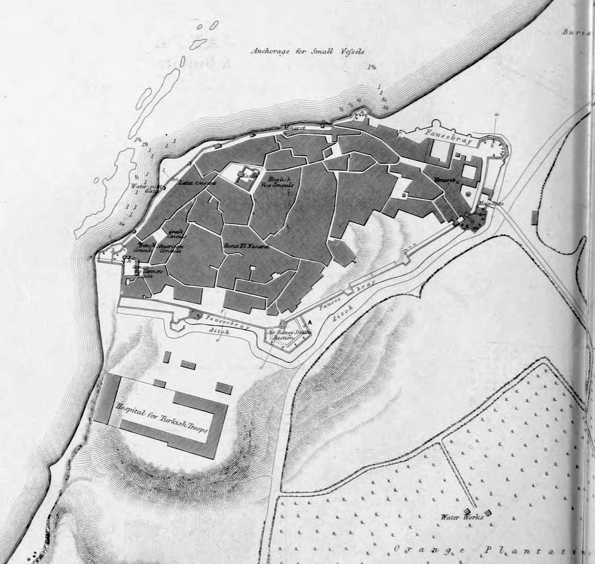
English: 1840–41 Royal Engineers map of Jaffa |
| תאריך יצירה | |
| מקור |
https://archive.org/details/papersonsubjects06grea/page/n97 Papers on subjects connected with the duties of the Corps Volume 6 1843 Chapter 3: Notes on Acre and some of the Coast Defences of Syria by Ralph Carr Alderson Pages 19-62 |
| יוצר | UK Government - Royal Engineers Corps |
רישיון
|
יצירה זו נמצאת בנחלת הכלל במדינת המקור ובמדינות אחרות בהם תקופת זכויות היוצרים היא משך חיי היוצר ו-70 שנה (או פחות) מפטירתו.
| |
| הקובץ הזה זוהה כקובץ חופשי מכל מגבלה ידועה תחת חוק זכויות היוצרים, כולל כל הזכויות הקשורות והסמוכות. | |
קובץ מדיה זה נמצא ברשות הציבור בארצות הברית. זה תקף לעבודות אמריקניות שבהן זכויות היוצרים פגו, לעתים מסיבה שהפרסום הראשון היה לפני 1 בינואר 1929. ראו דף זה להסבר נוסף.
|
 | |
 |
תמונה זו עשויה שלא להיות תחת רשות הציבור מחוץ לארצות הברית (זה נכון במיוחד במדינות ובאזורים שבהם לא חל rule of the shorter term עבור יצירות אמריקניות, ובהן קנדה, סין היבשתית (לא כולל הונג קונג ומקאו), גרמניה, מקסיקו, ושוויץ). היוצר ושנת הפרסום הם מידע חיוני שחובה לציין. ראו הסבר על רשות הציבור וזכויות יוצרים למידע נוסף.
|
היסטוריית הקובץ
ניתן ללחוץ על תאריך/שעה כדי לראות את הקובץ כפי שנראה באותו זמן.
| תאריך/שעה | תמונה ממוזערת | ממדים | משתמש | הערה | |
|---|---|---|---|---|---|
| נוכחית | 04:15, 29 בדצמבר 2019 | | 1,955 × 2,059 (961 ק"ב) | Onceinawhile | zoomed in, whiten |
| 03:55, 29 בדצמבר 2019 |  | 3,091 × 2,329 (475 ק"ב) | Onceinawhile | User created page with UploadWizard |
שימוש בקובץ
הדף הבא משתמש בקובץ הזה:
שימוש גלובלי בקובץ
אתרי הוויקי השונים הבאים משתמשים בקובץ זה:
- שימוש באתר ar.wikipedia.org
- שימוש באתר en.wikipedia.org
- שימוש באתר es.wikipedia.org
- שימוש באתר fa.wikipedia.org
- שימוש באתר fi.wikipedia.org
- שימוש באתר no.wikipedia.org
- שימוש באתר simple.wikipedia.org
- שימוש באתר uz.wikipedia.org