קובץ:KlamathBasin-location.jpg

גודל התצוגה המקדימה הזאת: 460 × 599 פיקסלים. רזולוציות אחרות: 184 × 240 פיקסלים | 369 × 480 פיקסלים | 768 × 1,000 פיקסלים.
לקובץ המקורי (768 × 1,000 פיקסלים, גודל הקובץ: 261 ק"ב, סוג MIME: image/jpeg)
| זהו קובץ שמקורו במיזם ויקישיתוף. תיאורו בדף תיאור הקובץ המקורי (בעברית) מוצג למטה. |
תקציר
| תיאור |
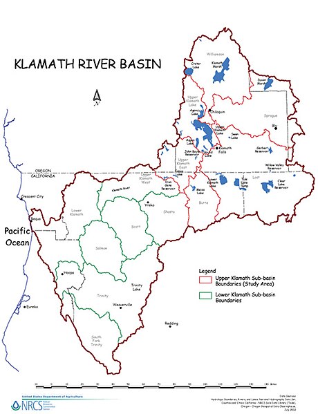
English: Map of the Klamath River watershed — showing sub-basin boundaries, in northwestern California and southern Oregon.
|
| מקור | USDA website |
| יוצר | U.S. Department of Agriculture (USDA) Natural Resources Conservation Service (NRCS) |
רישיון
| This image is a work of the Natural Resources Conservation Service, part of the United States Department of Agriculture, taken or made as part of an employee's official duties. As a work of the U.S. federal government, the image is in the public domain in the United States. |
יומן העלאה מקורי
הועבר מ- en.wikipedia לוויקישיתוףעל ידי Teratornis באמצעות CommonsHelper.
תיאור הקובץ המקורי נמצא כאן. כל שמות המשתמשים הבאים מתייחסים ל-en.wikipedia.
- 2009-08-22 04:47 Shannon1 850×1100× (283498 bytes) {{Information |Description = Map of the [[Klamath River]] watershed showing sub-basin boundaries |Source = [http://www.nrcs.usda.gov/feature/klamath/images/kb-location.jpg USDA website] |Date = |Author = [[U.S. Department
היסטוריית הקובץ
ניתן ללחוץ על תאריך/שעה כדי לראות את הקובץ כפי שנראה באותו זמן.
| תאריך/שעה | תמונה ממוזערת | ממדים | משתמש | הערה | |
|---|---|---|---|---|---|
| נוכחית | 11:21, 29 באפריל 2013 | | 1,000 × 768 (261 ק"ב) | Ras67 | losslessly cropped with Jpegcrop |
| 10:57, 4 באוקטובר 2009 |  | 1,100 × 850 (277 ק"ב) | File Upload Bot (Magnus Manske) | {{BotMoveToCommons|en.wikipedia|year={{subst:CURRENTYEAR}}|month={{subst:CURRENTMONTHNAME}}|day={{subst:CURRENTDAY}}}} {{Information |Description={{en|Map of the en:Klamath River watershed showing sub-basin boundaries}} |Source=Transferred from [ht |
שימוש בקובץ
הדפים הבאים משתמשים בקובץ הזה:
שימוש גלובלי בקובץ
אתרי הוויקי השונים הבאים משתמשים בקובץ זה:
- שימוש באתר en.wikipedia.org
- Klamath, California
- Klamath Falls, Oregon
- Klamath County, California
- Klamath River
- Upper Klamath Lake
- Shasta River
- Trinity River (California)
- Williamson River (Oregon)
- Sprague River (Oregon)
- Lost River (California)
- Weitchpec, California
- Klamath National Forest
- Six Rivers National Forest
- Tule Lake
- Link River Dam
- Klamath Project
- Lake Ewauna
- Lower Klamath Lake
- Salmon River (California)
- Scott River
- Happy Camp, California
- Klamath Basin
- Orleans, California
- Klamath Glen, California
- John C. Boyle Dam
- Template:Klamath River
- Klamath Diversion
- Course of the Klamath River
- Grouse Creek (Humboldt County, California)
- Boise Creek
- Copper Creek (California)
- Iron Gate Dam (California)
- Copco Lake
- Klamath River Hydroelectric Project
- שימוש באתר es.wikipedia.org
- שימוש באתר ml.wikipedia.org