קובץ:Plantations in Ireland.png
גודל התצוגה המקדימה הזאת: 477 × 599 פיקסלים. רזולוציות אחרות: 191 × 240 פיקסלים | 382 × 480 פיקסלים | 700 × 879 פיקסלים.
לקובץ המקורי (700 × 879 פיקסלים, גודל הקובץ: 252 ק"ב, סוג MIME: image/png)
| זהו קובץ שמקורו במיזם ויקישיתוף. תיאורו בדף תיאור הקובץ המקורי (בעברית) מוצג למטה. |
תקציר
| תיאור |
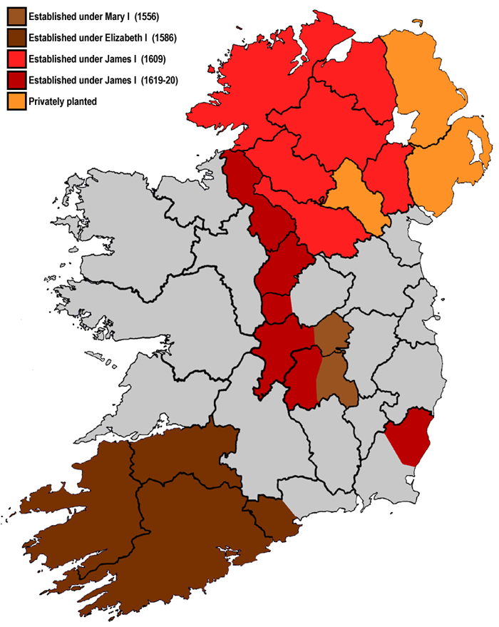
English: A map highlighting the areas subjected to British plantations in Ireland. Although the plantations in Munster did not cover the entire shaded area, it has been simplified for the purposes of this map. Modern county boundaries are also shown.
Hrvatski: karta britanskog Plantažiranja Irske po etapama |
||
| תאריך יצירה | |||
| מקור | Based on [1], [2], [3]. | ||
| יוצר | User:Asarlaí | ||
| גרסאות אחרות |
|

![[1]](http://www.maddybenny.com/images/plant2.gif)
![[3]](https://upload.wikimedia.org/wikipedia/commons/4/4a/Map_of_Ireland_in_1609.gif)
רישיון
אני, בעל זכויות היוצרים על היצירה הזאת, מפרסם אותה בזאת תחת הרישיונות הבאים:

|
מוענקת בכך הרשות להעתיק, להפיץ או לשנות את המסמך הזה, לפי תנאי הרישיון לשימוש חופשי במסמכים של גנו, גרסה 1.2 או כל גרסה מאוחרת יותר שתפורסם על־ידי המוסד לתוכנה חופשית; ללא פרקים קבועים, ללא טקסט עטיפה קדמית וללא טקסט עטיפה אחורית. עותק של הרישיון כלול בפרק שכותרתו הרישיון לשימוש חופשי במסמכים של גנו. |
This file is licensed under the Creative Commons Attribution-Share Alike 4.0 International, 3.0 Unported, 2.5 Generic, 2.0 Generic and 1.0 Generic license.
- הנכם רשאים:
- לשתף – להעתיק, להפיץ ולהעביר את העבודה
- לערבב בין עבודות – להתאים את העבודה
- תחת התנאים הבאים:
- ייחוס – יש לתת ייחוס הולם, לתת קישור לרישיון, ולציין אם נעשו שינויים. אפשר לעשות את זה בכל צורה סבירה, אבל לא בשום צורה שמשתמע ממנה שמעניק הרישיון תומך בך או בשימוש שלך.
- שיתוף זהה – אם תיצרו רמיקס, תשנו, או תבנו על החומר, חובה עליכם להפיץ את התרומות שלך לפי תנאי רישיון זהה או תואם למקור.
הנכם מוזמנים לבחור את הרישיון הרצוי בעיניכם.
היסטוריית הקובץ
ניתן ללחוץ על תאריך/שעה כדי לראות את הקובץ כפי שנראה באותו זמן.
| תאריך/שעה | תמונה ממוזערת | ממדים | משתמש | הערה | |
|---|---|---|---|---|---|
| נוכחית | 07:54, 17 ביוני 2009 | | 879 × 700 (252 ק"ב) | Asarlaí | {{Information |Description=A map highlighting the areas subjected to British plantations in Ireland. Modern county boundaries are also shown. |Source=Based on [http://www.maddybenny.com/images/plant2.gif] and [http://en.wikipedia.org/wiki/Plantations_of_I |
שימוש בקובץ
הדפים הבאים משתמשים בקובץ הזה:
שימוש גלובלי בקובץ
אתרי הוויקי השונים הבאים משתמשים בקובץ זה:
- שימוש באתר ar.wikipedia.org
- שימוש באתר ast.wikipedia.org
- שימוש באתר ca.wikipedia.org
- שימוש באתר el.wikipedia.org
- שימוש באתר en.wikipedia.org
- שימוש באתר es.wikipedia.org
- שימוש באתר eu.wikipedia.org
- שימוש באתר fr.wikipedia.org
- שימוש באתר ga.wikipedia.org
- שימוש באתר gl.wikipedia.org
- שימוש באתר it.wikipedia.org
- שימוש באתר ro.wikipedia.org
- שימוש באתר tr.wikipedia.org