קובץ:South America southern tip pol.png

גודל התצוגה המקדימה הזאת: 800 × 494 פיקסלים. רזולוציות אחרות: 320 × 198 פיקסלים | 640 × 395 פיקסלים | 1,024 × 632 פיקסלים | 1,280 × 790 פיקסלים | 2,560 × 1,581 פיקסלים | 3,859 × 2,383 פיקסלים.
לקובץ המקורי (3,859 × 2,383 פיקסלים, גודל הקובץ: 596 ק"ב, סוג MIME: image/png)
| זהו קובץ שמקורו במיזם ויקישיתוף. תיאורו בדף תיאור הקובץ המקורי (בעברית) מוצג למטה. |
תקציר
| תיאור |
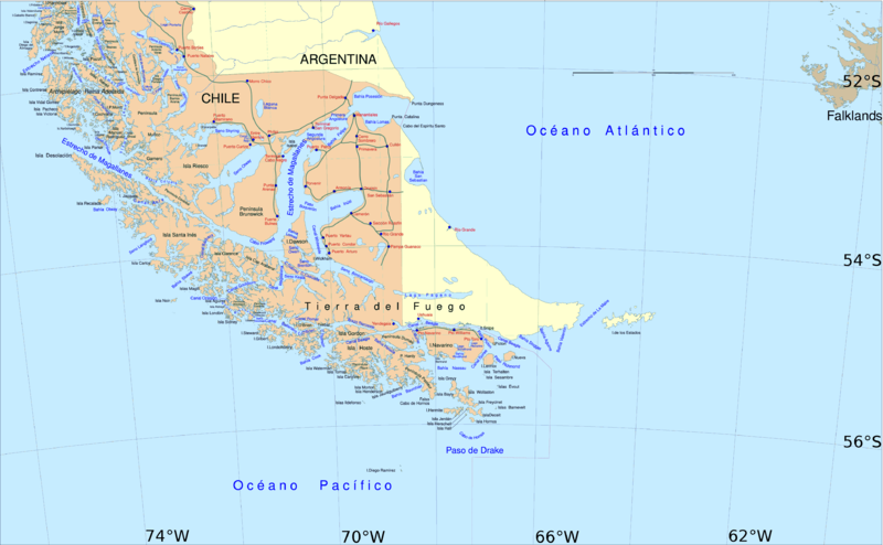
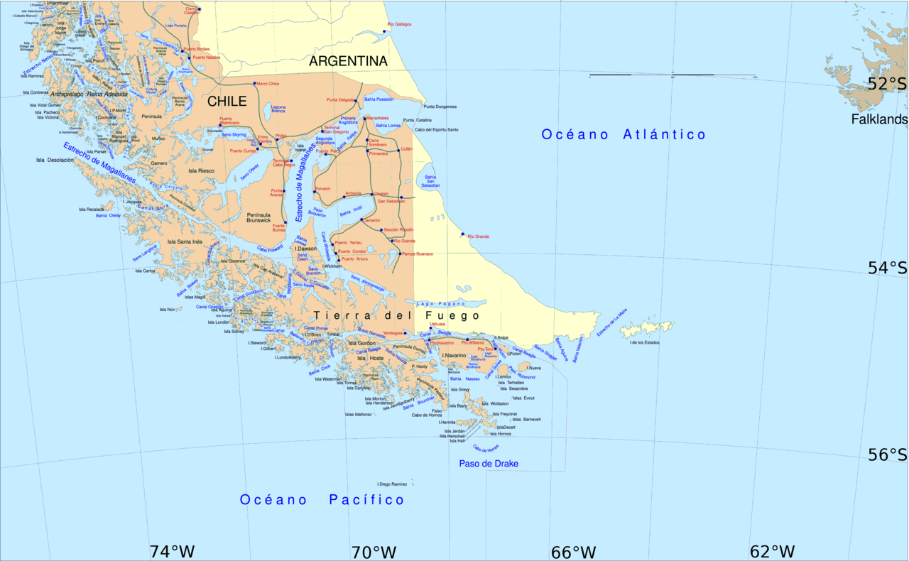
English: Political map of southern Chile and Argentina, from Straits of Magellan to Cape Horn.
Español: Mapa político del sur de Chile y la Argentina, entre el estrecho de Magallanes y el cabo de Hornos. |
||||
| תאריך יצירה | |||||
| מקור | File:Sur2.gif | ||||
| יוצר | User:Createaccount | ||||
| אישורים והיתרים (שימוש חוזר בקובץ זה) |
|
||||
| גרסאות אחרות | Derivative works of this file: Metula.svg |
רישיון

|
מוענקת בכך הרשות להעתיק, להפיץ או לשנות את המסמך הזה, לפי תנאי הרישיון לשימוש חופשי במסמכים של גנו, גרסה 1.2 או כל גרסה מאוחרת יותר שתפורסם על־ידי המוסד לתוכנה חופשית; ללא פרקים קבועים, ללא טקסט עטיפה קדמית וללא טקסט עטיפה אחורית. עותק של הרישיון כלול בפרק שכותרתו הרישיון לשימוש חופשי במסמכים של גנו. |
| הקובץ הזה מתפרסם לפי תנאי רישיון קריאייטיב קומונז ייחוס-שיתוף זהה 3.0 לא מותאם. | ||
| ||
| תבנית רישוי זו הוספה לקובץ כחלק מעדכון רישיון GFDL. |
היסטוריית הקובץ
ניתן ללחוץ על תאריך/שעה כדי לראות את הקובץ כפי שנראה באותו זמן.
| תאריך/שעה | תמונה ממוזערת | ממדים | משתמש | הערה | |
|---|---|---|---|---|---|
| נוכחית | 17:06, 30 באפריל 2016 | | 2,383 × 3,859 (596 ק"ב) | Hohum | Cartographic colours |
| 14:09, 3 באפריל 2013 |  | 2,383 × 3,859 (597 ק"ב) | Keysanger | Margin right and top cropped | |
| 13:47, 3 באפריל 2013 |  | 2,383 × 3,859 (597 ק"ב) | Keysanger | "Estrecho Nelson" added Bigger Latitude and Longitude within the image empty margin cropped | |
| 22:30, 3 במאי 2009 |  | 2,441 × 3,894 (639 ק"ב) | Pitichinaccio | different colour | |
| 22:29, 3 במאי 2009 |  | 2,441 × 3,894 (639 ק"ב) | Pitichinaccio | {{Information |Description={{en|1=political map of southern Chile/Argentina: From Straits of Magellan to Cape Horn}} |Source=File:Sur2.gif |Author=User:Createaccount |Date=2008 |Permission={{GFDL-GMT}}} |other_versions=File:Sur2.gif }} <!-- |
שימוש בקובץ
הדף הבא משתמש בקובץ הזה:
שימוש גלובלי בקובץ
אתרי הוויקי השונים הבאים משתמשים בקובץ זה:
- שימוש באתר af.wikipedia.org
- שימוש באתר als.wikipedia.org
- שימוש באתר ar.wikipedia.org
- שימוש באתר ast.wikipedia.org
- שימוש באתר br.wikipedia.org
- שימוש באתר ca.wikipedia.org
- שימוש באתר de.wikipedia.org
- שימוש באתר de.wiktionary.org
- שימוש באתר el.wikipedia.org
- שימוש באתר en.wikipedia.org
- Cape Froward
- Porvenir, Chile
- Santa Inés Island
- Puerto Toro
- False Cape Horn
- Puerto del Hambre
- Maritime history of California
- Brunswick Peninsula
- Almirantazgo Fjord
- Fjord of the Mountains
- Primera Angostura
- Aracena Island
- Punta Dúngeness
- Muñoz Gamero Peninsula
- Seno Otway
- Mitre Peninsula
- Marlborough (1876 ship)