קובץ:West Bank Access Restrictions June 2020.pdf

לקובץ המקורי (4,964 × 7,020 פיקסלים, גודל הקובץ: 15.18 מ"ב, סוג MIME: application/pdf)
| זהו קובץ שמקורו במיזם ויקישיתוף. תיאורו בדף תיאור הקובץ המקורי (בעברית) מוצג למטה. |
תקציר
| תיאור |
English: West Bank access restrictions map |
| תאריך יצירה | |
| מקור | https://www.ochaopt.org/sites/default/files/westbank_a0_25_06_2020_final.pdf |
| יוצר | United Nations OCHA oPt |
רישיון
| This image is a map derived from a United Nations map.
Unless stated otherwise, UN maps are to be considered in the public domain. This applies worldwide. UN maps are, in principle, open source material and you can use them in your work or for making your own map. UN requests however that you delete the UN name, logo and reference number upon any modification to the map. Content of your map will be your responsibility. You can state in your publication, if you wish, something like: based on UN map … (map name, map number, revision number and date). See: Geospatial Information Section. And: Geospatial, location data for a better world. |
 |
היסטוריית הקובץ
ניתן ללחוץ על תאריך/שעה כדי לראות את הקובץ כפי שנראה באותו זמן.
| תאריך/שעה | תמונה ממוזערת | ממדים | משתמש | הערה | |
|---|---|---|---|---|---|
| נוכחית | 16:53, 20 במאי 2021 | 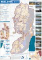 | 7,020 × 4,964 (15.18 מ"ב) | Jul059 | Lossless file size reduction |
| 23:33, 14 בדצמבר 2020 | אין תמונה ממוזערת | 0 × 0 (15.92 מ"ב) | Veggies | Updated for 2020 | |
| 20:32, 27 בינואר 2016 | אין תמונה ממוזערת | 0 × 0 (17.08 מ"ב) | Triggerhippie4 | User created page with UploadWizard |
שימוש בקובץ
הדפים הבאים משתמשים בקובץ הזה:
שימוש גלובלי בקובץ
אתרי הוויקי השונים הבאים משתמשים בקובץ זה:
- שימוש באתר ar.wikipedia.org
- שימוש באתר arz.wikipedia.org
- שימוש באתר azb.wikipedia.org
- שימוש באתר cs.wikipedia.org
- שימוש באתר de.wikipedia.org
- שימוש באתר de.wikivoyage.org
- שימוש באתר el.wikipedia.org
- שימוש באתר en.wikipedia.org
- Israeli settlement
- West Bank
- Population statistics for Israeli settlements in the West Bank
- Israeli checkpoint
- Settler colonialism
- Area C (West Bank)
- User:Falcaorib
- Palestinian enclaves
- Zionism as settler colonialism
- User:Carter McCrae/Israeli–Palestinian conflict
- Israeli incursions in the West Bank during the Israel–Hamas war
- שימוש באתר en.wikivoyage.org
- שימוש באתר eo.wikipedia.org
- שימוש באתר eu.wikipedia.org
- שימוש באתר fa.wikipedia.org
- שימוש באתר fr.wikipedia.org
- שימוש באתר fy.wikipedia.org
- שימוש באתר ha.wikipedia.org
- שימוש באתר he.wikiquote.org
- שימוש באתר id.wikipedia.org
- שימוש באתר it.wikivoyage.org
- שימוש באתר ja.wikipedia.org
- שימוש באתר ka.wikipedia.org
- שימוש באתר ko.wikipedia.org
- שימוש באתר nl.wikipedia.org
- שימוש באתר nl.wikinews.org
- שימוש באתר pcm.wikipedia.org
- שימוש באתר pl.wikipedia.org
- שימוש באתר pt.wikipedia.org
- שימוש באתר ru.wikipedia.org
- שימוש באתר sl.wikipedia.org
- שימוש באתר tl.wikipedia.org
- שימוש באתר uk.wikipedia.org